You are here: Home > Network List > MQ - Martinique Seismic and Volcano Observatory Network Stations List
> Station ZAM Zone Aero-Militaire - Martinique > Earthquake Result Viewer
ZAM Zone Aero-Militaire - Martinique - Earthquake Result Viewer

| Earthquake location: |
Dodecanese Islands, Greece |
| Earthquake latitude/longitude: |
37.9/26.8 |
| Earthquake time(UTC): |
2020/10/30 (304) 11:51:27 GMT |
| Earthquake Depth: |
21 km |
| Earthquake Magnitude: |
7.0 mww |
| Earthquake Catalog/Contributor: |
NEIC PDE/us |
|
| Network: |
MQ Martinique Seismic and Volcano Observatory Network |
| Station: |
ZAM Zone Aero-Militaire - Martinique |
| Lat/Lon: |
14.59 N/61.02 W |
| Elevation: |
11 m |
|
| Distance: |
79.5 deg |
| Az: |
280.27 deg |
| Baz: |
53.494 deg |
| Ray Param: |
0.048907436 |
| Estimated Moho Depth: |
12.5 km |
| Estimated Crust Vp/Vs: |
1.60 |
| Assumed Crust Vp: |
5.88 km/s |
| Estimated Crust Vs: |
3.675 km/s |
| Estimated Crust Poisson's Ratio: |
0.18 |
|
| Radial Match: |
86.32351 % |
| Radial Bump: |
400 |
| Transverse Match: |
69.31212 % |
| Transverse Bump: |
400 |
| SOD ConfigId: |
23341671 |
| Insert Time: |
2020-11-13 13:06:42.309 +0000 |
| GWidth: |
2.5 |
| Max Bumps: |
400 |
| Tol: |
0.001 |
|
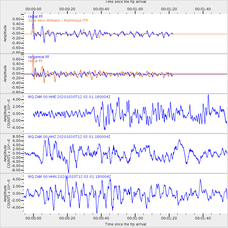
Signal To Noise
| Channel | StoN | STA | LTA |
| MQ:ZAM:00:HHZ:20201030T12:03:01.180004Z | 4.9321475 | 1.74283E-6 | 3.533613E-7 |
| MQ:ZAM:00:HHN:20201030T12:03:01.180004Z | 1.0474458 | 7.909087E-7 | 7.5508314E-7 |
| MQ:ZAM:00:HHE:20201030T12:03:01.180004Z | 1.2198306 | 5.877347E-7 | 4.8181664E-7 |
| Arrivals |
| Ps | 1.3 SECOND |
| PpPs | 5.4 SECOND |
| PsPs/PpSs | 6.7 SECOND |


