You are here: Home > Network List > N4 - Central and EAstern US Network Stations List
> Station 146B Union, MS, USA > Earthquake Result Viewer
146B Union, MS, USA - Earthquake Result Viewer
| Earthquake location: |
Dodecanese Islands, Greece |
| Earthquake latitude/longitude: |
37.9/26.8 |
| Earthquake time(UTC): |
2020/10/30 (304) 11:51:27 GMT |
| Earthquake Depth: |
21 km |
| Earthquake Magnitude: |
7.0 mww |
| Earthquake Catalog/Contributor: |
NEIC PDE/us |
|
| Network: |
N4 Central and EAstern US Network |
| Station: |
146B Union, MS, USA |
| Lat/Lon: |
32.64 N/89.06 W |
| Elevation: |
161 m |
|
| Distance: |
87.8 deg |
| Az: |
310.547 deg |
| Baz: |
45.42 deg |
| Ray Param: |
0.043007627 |
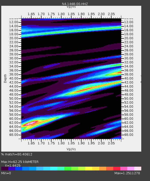
| Estimated Moho Depth: |
62.25 km |
| Estimated Crust Vp/Vs: |
1.64 |
| Assumed Crust Vp: |
6.201 km/s |
| Estimated Crust Vs: |
3.776 km/s |
| Estimated Crust Poisson's Ratio: |
0.21 |
|
| Radial Match: |
80.40612 % |
| Radial Bump: |
317 |
| Transverse Match: |
49.373535 % |
| Transverse Bump: |
286 |
| SOD ConfigId: |
23341671 |
| Insert Time: |
2020-11-13 13:06:50.779 +0000 |
| GWidth: |
2.5 |
| Max Bumps: |
400 |
| Tol: |
0.001 |
|

Signal To Noise
| Channel | StoN | STA | LTA |
| N4:146B:00:HHZ:20201030T12:03:43.808972Z | 6.3043475 | 2.4060507E-6 | 3.8164941E-7 |
| N4:146B:00:HH1:20201030T12:03:43.808972Z | 0.6712515 | 1.5927598E-6 | 2.3728214E-6 |
| N4:146B:00:HH2:20201030T12:03:43.808972Z | 1.3451142 | 3.3774872E-6 | 2.5109296E-6 |
| Arrivals |
| Ps | 6.6 SECOND |
| PpPs | 26 SECOND |
| PsPs/PpSs | 33 SECOND |


