You are here: Home > Network List > N4 - Central and EAstern US Network Stations List
> Station P43A Skaggs, Pawnee, IL, USA > Earthquake Result Viewer
P43A Skaggs, Pawnee, IL, USA - Earthquake Result Viewer
| Earthquake location: |
Dodecanese Islands, Greece |
| Earthquake latitude/longitude: |
37.9/26.8 |
| Earthquake time(UTC): |
2020/10/30 (304) 11:51:27 GMT |
| Earthquake Depth: |
21 km |
| Earthquake Magnitude: |
7.0 mww |
| Earthquake Catalog/Contributor: |
NEIC PDE/us |
|
| Network: |
N4 Central and EAstern US Network |
| Station: |
P43A Skaggs, Pawnee, IL, USA |
| Lat/Lon: |
39.64 N/89.52 W |
| Elevation: |
176 m |
|
| Distance: |
83.2 deg |
| Az: |
315.81 deg |
| Baz: |
45.558 deg |
| Ray Param: |
0.046329778 |
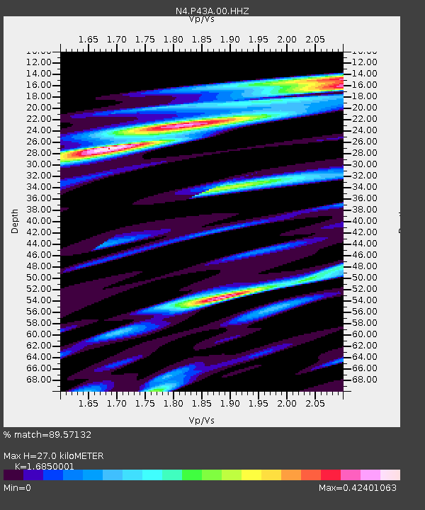
| Estimated Moho Depth: |
27.0 km |
| Estimated Crust Vp/Vs: |
1.69 |
| Assumed Crust Vp: |
6.444 km/s |
| Estimated Crust Vs: |
3.824 km/s |
| Estimated Crust Poisson's Ratio: |
0.23 |
|
| Radial Match: |
89.57132 % |
| Radial Bump: |
400 |
| Transverse Match: |
61.964363 % |
| Transverse Bump: |
363 |
| SOD ConfigId: |
23341671 |
| Insert Time: |
2020-11-13 13:07:59.139 +0000 |
| GWidth: |
2.5 |
| Max Bumps: |
400 |
| Tol: |
0.001 |
|

Signal To Noise
| Channel | StoN | STA | LTA |
| N4:P43A:00:HHZ:20201030T12:03:20.828991Z | 3.723146 | 2.870522E-6 | 7.7099367E-7 |
| N4:P43A:00:HH1:20201030T12:03:20.828991Z | 2.1671484 | 1.1377209E-6 | 5.2498524E-7 |
| N4:P43A:00:HH2:20201030T12:03:20.828991Z | 1.5916787 | 8.286126E-7 | 5.2059033E-7 |
| Arrivals |
| Ps | 2.9 SECOND |
| PpPs | 11 SECOND |
| PsPs/PpSs | 14 SECOND |


