You are here: Home > Network List > TA - USArray Transportable Network (new EarthScope stations) Stations List
> Station F14K Arctic Creek, AK, USA > Earthquake Result Viewer
F14K Arctic Creek, AK, USA - Earthquake Result Viewer
| Earthquake location: |
Dodecanese Islands, Greece |
| Earthquake latitude/longitude: |
37.9/26.8 |
| Earthquake time(UTC): |
2020/10/30 (304) 11:51:27 GMT |
| Earthquake Depth: |
21 km |
| Earthquake Magnitude: |
7.0 mww |
| Earthquake Catalog/Contributor: |
NEIC PDE/us |
|
| Network: |
TA USArray Transportable Network (new EarthScope stations) |
| Station: |
F14K Arctic Creek, AK, USA |
| Lat/Lon: |
65.47 N/166.33 W |
| Elevation: |
266 m |
|
| Distance: |
76.4 deg |
| Az: |
5.593 deg |
| Baz: |
349.358 deg |
| Ray Param: |
0.050985023 |
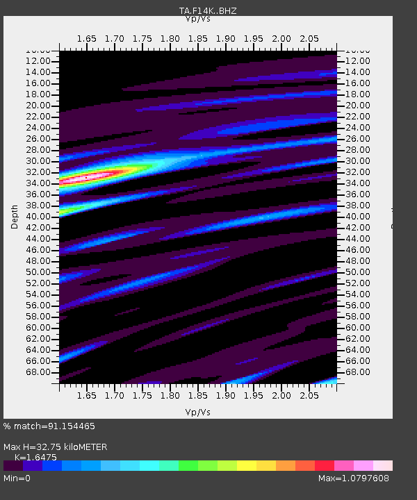
| Estimated Moho Depth: |
32.75 km |
| Estimated Crust Vp/Vs: |
1.65 |
| Assumed Crust Vp: |
6.307 km/s |
| Estimated Crust Vs: |
3.828 km/s |
| Estimated Crust Poisson's Ratio: |
0.21 |
|
| Radial Match: |
91.154465 % |
| Radial Bump: |
400 |
| Transverse Match: |
73.232285 % |
| Transverse Bump: |
400 |
| SOD ConfigId: |
23341671 |
| Insert Time: |
2020-11-13 13:14:12.763 +0000 |
| GWidth: |
2.5 |
| Max Bumps: |
400 |
| Tol: |
0.001 |
|

Signal To Noise
| Channel | StoN | STA | LTA |
| TA:F14K: :BHZ:20201030T12:02:44.250012Z | 5.3512573 | 1.8374202E-6 | 3.4336233E-7 |
| TA:F14K: :BHN:20201030T12:02:44.250012Z | 2.4777958 | 6.6997166E-7 | 2.703902E-7 |
| TA:F14K: :BHE:20201030T12:02:44.250012Z | 2.5722144 | 3.7961092E-7 | 1.4758137E-7 |
| Arrivals |
| Ps | 3.5 SECOND |
| PpPs | 13 SECOND |
| PsPs/PpSs | 17 SECOND |


