You are here: Home > Network List > TA - USArray Transportable Network (new EarthScope stations) Stations List
> Station I29M Ogilvie Camp, Yukon, CA > Earthquake Result Viewer
I29M Ogilvie Camp, Yukon, CA - Earthquake Result Viewer
| Earthquake location: |
Dodecanese Islands, Greece |
| Earthquake latitude/longitude: |
37.9/26.8 |
| Earthquake time(UTC): |
2020/10/30 (304) 11:51:27 GMT |
| Earthquake Depth: |
21 km |
| Earthquake Magnitude: |
7.0 mww |
| Earthquake Catalog/Contributor: |
NEIC PDE/us |
|
| Network: |
TA USArray Transportable Network (new EarthScope stations) |
| Station: |
I29M Ogilvie Camp, Yukon, CA |
| Lat/Lon: |
65.36 N/138.31 W |
| Elevation: |
602 m |
|
| Distance: |
76.4 deg |
| Az: |
353.631 deg |
| Baz: |
12.08 deg |
| Ray Param: |
0.051008884 |
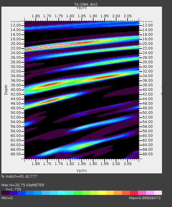
| Estimated Moho Depth: |
20.75 km |
| Estimated Crust Vp/Vs: |
1.73 |
| Assumed Crust Vp: |
6.566 km/s |
| Estimated Crust Vs: |
3.806 km/s |
| Estimated Crust Poisson's Ratio: |
0.25 |
|
| Radial Match: |
91.61777 % |
| Radial Bump: |
400 |
| Transverse Match: |
82.04802 % |
| Transverse Bump: |
400 |
| SOD ConfigId: |
23341671 |
| Insert Time: |
2020-11-13 13:14:50.630 +0000 |
| GWidth: |
2.5 |
| Max Bumps: |
400 |
| Tol: |
0.001 |
|

Signal To Noise
| Channel | StoN | STA | LTA |
| TA:I29M: :BHZ:20201030T12:02:44.050Z | 8.316544 | 2.3717432E-6 | 2.8518377E-7 |
| TA:I29M: :BHN:20201030T12:02:44.050Z | 3.547089 | 1.0596774E-6 | 2.9874562E-7 |
| TA:I29M: :BHE:20201030T12:02:44.050Z | 1.0784862 | 3.074556E-7 | 2.8508072E-7 |
| Arrivals |
| Ps | 2.4 SECOND |
| PpPs | 8.3 SECOND |
| PsPs/PpSs | 11 SECOND |


