You are here: Home > Network List > TA - USArray Transportable Network (new EarthScope stations) Stations List
> Station L15K Ungalak Mountain, AK, USA > Earthquake Result Viewer
L15K Ungalak Mountain, AK, USA - Earthquake Result Viewer
| Earthquake location: |
Dodecanese Islands, Greece |
| Earthquake latitude/longitude: |
37.9/26.8 |
| Earthquake time(UTC): |
2020/10/30 (304) 11:51:27 GMT |
| Earthquake Depth: |
21 km |
| Earthquake Magnitude: |
7.0 mww |
| Earthquake Catalog/Contributor: |
NEIC PDE/us |
|
| Network: |
TA USArray Transportable Network (new EarthScope stations) |
| Station: |
L15K Ungalak Mountain, AK, USA |
| Lat/Lon: |
61.68 N/161.49 W |
| Elevation: |
219 m |
|
| Distance: |
80.5 deg |
| Az: |
3.991 deg |
| Baz: |
353.372 deg |
| Ray Param: |
0.04819804 |
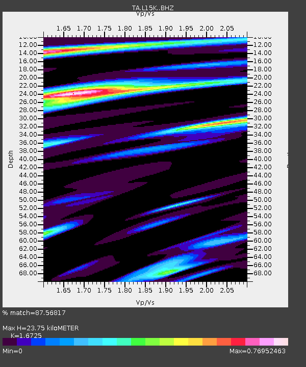
| Estimated Moho Depth: |
23.75 km |
| Estimated Crust Vp/Vs: |
1.67 |
| Assumed Crust Vp: |
6.182 km/s |
| Estimated Crust Vs: |
3.696 km/s |
| Estimated Crust Poisson's Ratio: |
0.22 |
|
| Radial Match: |
87.56817 % |
| Radial Bump: |
380 |
| Transverse Match: |
70.34801 % |
| Transverse Bump: |
400 |
| SOD ConfigId: |
23341671 |
| Insert Time: |
2020-11-13 13:15:02.493 +0000 |
| GWidth: |
2.5 |
| Max Bumps: |
400 |
| Tol: |
0.001 |
|

Signal To Noise
| Channel | StoN | STA | LTA |
| TA:L15K: :BHZ:20201030T12:03:06.724987Z | 6.672193 | 2.1174608E-6 | 3.17356E-7 |
| TA:L15K: :BHN:20201030T12:03:06.724987Z | 4.181572 | 9.739526E-7 | 2.3291544E-7 |
| TA:L15K: :BHE:20201030T12:03:06.724987Z | 0.49425963 | 1.2366891E-7 | 2.5021043E-7 |
| Arrivals |
| Ps | 2.7 SECOND |
| PpPs | 10.0 SECOND |
| PsPs/PpSs | 13 SECOND |


