You are here: Home > Network List > TX - Texas Seismological Network Stations List
> Station WTFS Witchita Falls > Earthquake Result Viewer
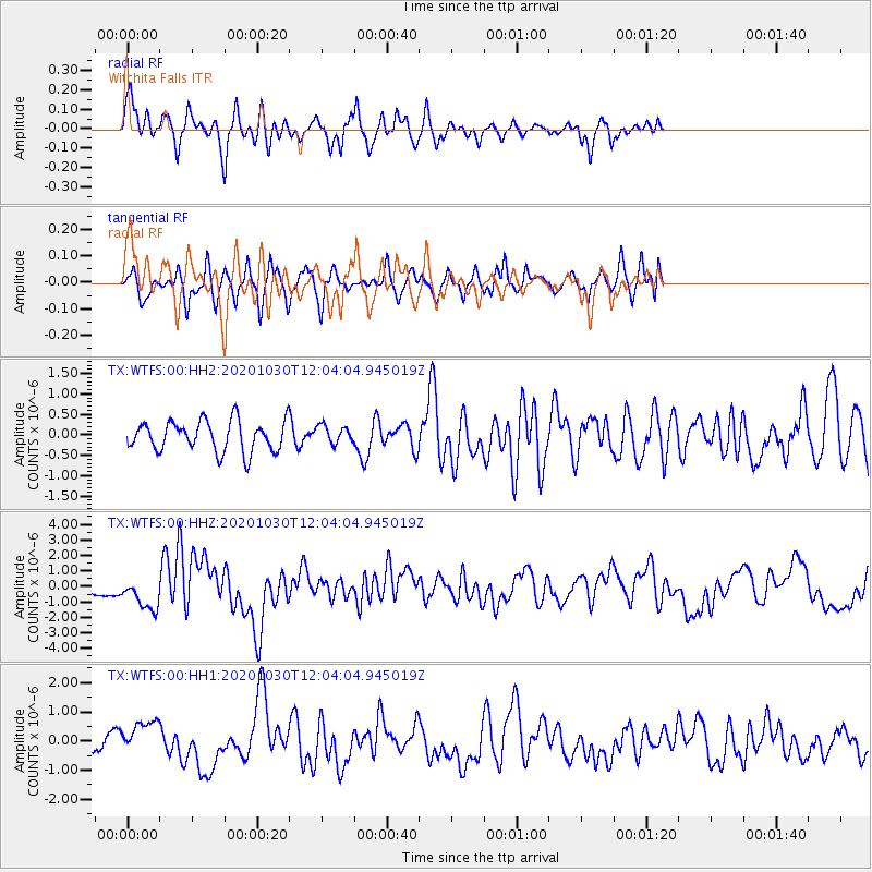
WTFS Witchita Falls - Earthquake Result Viewer
*The percent match for this event was below the threshold and hence no stack was calculated.
| Earthquake location: |
Dodecanese Islands, Greece |
| Earthquake latitude/longitude: |
37.9/26.8 |
| Earthquake time(UTC): |
2020/10/30 (304) 11:51:27 GMT |
| Earthquake Depth: |
21 km |
| Earthquake Magnitude: |
7.0 mww |
| Earthquake Catalog/Contributor: |
NEIC PDE/us |
|
| Network: |
TX Texas Seismological Network |
| Station: |
WTFS Witchita Falls |
| Lat/Lon: |
33.77 N/98.46 W |
| Elevation: |
277 m |
|
| Distance: |
92.4 deg |
| Az: |
317.091 deg |
| Baz: |
40.271 deg |
| Ray Param: |
$rayparam |
*The percent match for this event was below the threshold and hence was not used in the summary stack. |
|
| Radial Match: |
66.18169 % |
| Radial Bump: |
343 |
| Transverse Match: |
50.99968 % |
| Transverse Bump: |
380 |
| SOD ConfigId: |
23341671 |
| Insert Time: |
2020-11-13 13:17:02.612 +0000 |
| GWidth: |
2.5 |
| Max Bumps: |
400 |
| Tol: |
0.001 |
|
Signal To Noise
| Channel | StoN | STA | LTA |
| TX:WTFS:00:HHZ:20201030T12:04:04.945019Z | 3.0904484 | 1.0398187E-6 | 3.3646208E-7 |
| TX:WTFS:00:HH1:20201030T12:04:04.945019Z | 1.109167 | 6.0851295E-7 | 5.486216E-7 |
| TX:WTFS:00:HH2:20201030T12:04:04.945019Z | 0.607397 | 2.2553587E-7 | 3.713154E-7 |
| Arrivals |
| Ps | |
| PpPs | |
| PsPs/PpSs | |


