You are here: Home > Network List > LD - Lamont-Doherty Cooperative Seismographic Network Stations List
> Station SDMD Soldier's Delight, Maryland > Earthquake Result Viewer
SDMD Soldier's Delight, Maryland - Earthquake Result Viewer
| Earthquake location: |
Northwest Of Kuril Islands |
| Earthquake latitude/longitude: |
47.8/146.2 |
| Earthquake time(UTC): |
2002/11/17 (321) 04:53:53 GMT |
| Earthquake Depth: |
459 km |
| Earthquake Magnitude: |
7.3 MW, 7.3 MW |
| Earthquake Catalog/Contributor: |
WHDF/NEIC |
|
| Network: |
LD Lamont-Doherty Cooperative Seismographic Network |
| Station: |
SDMD Soldier's Delight, Maryland |
| Lat/Lon: |
39.41 N/76.84 W |
| Elevation: |
212 m |
|
| Distance: |
85.1 deg |
| Az: |
32.059 deg |
| Baz: |
332.503 deg |
| Ray Param: |
0.04376592 |
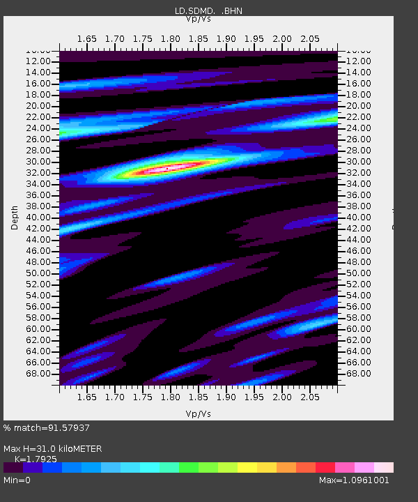
| Estimated Moho Depth: |
31.0 km |
| Estimated Crust Vp/Vs: |
1.79 |
| Assumed Crust Vp: |
6.419 km/s |
| Estimated Crust Vs: |
3.581 km/s |
| Estimated Crust Poisson's Ratio: |
0.27 |
|
| Radial Match: |
91.57937 % |
| Radial Bump: |
320 |
| Transverse Match: |
82.11734 % |
| Transverse Bump: |
400 |
| SOD ConfigId: |
4714 |
| Insert Time: |
2010-03-09 03:11:28.252 +0000 |
| GWidth: |
2.5 |
| Max Bumps: |
400 |
| Tol: |
0.001 |
|
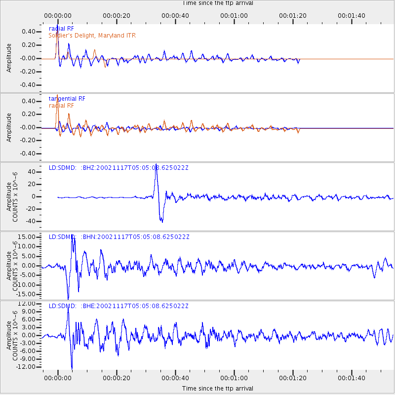
Signal To Noise
| Channel | StoN | STA | LTA |
| LD:SDMD: :BHN:20021117T05:05:08.625022Z | 9.8160095 | 6.199393E-6 | 6.3155943E-7 |
| LD:SDMD: :BHE:20021117T05:05:08.625022Z | 11.972211 | 4.1956146E-6 | 3.504461E-7 |
| LD:SDMD: :BHZ:20021117T05:05:08.625022Z | 38.02431 | 1.9392533E-5 | 5.1000353E-7 |
| Arrivals |
| Ps | 3.9 SECOND |
| PpPs | 13 SECOND |
| PsPs/PpSs | 17 SECOND |


