You are here: Home > Network List > LD - Lamont-Doherty Cooperative Seismographic Network Stations List
> Station UCCT University of Connecticut, Storrs, CT > Earthquake Result Viewer
UCCT University of Connecticut, Storrs, CT - Earthquake Result Viewer
| Earthquake location: |
North Of Svalbard |
| Earthquake latitude/longitude: |
80.3/-1.9 |
| Earthquake time(UTC): |
2009/03/06 (065) 10:50:29 GMT |
| Earthquake Depth: |
9.0 km |
| Earthquake Magnitude: |
6.6 MB, 6.5 MS, 6.5 MW, 6.4 MW |
| Earthquake Catalog/Contributor: |
WHDF/NEIC |
|
| Network: |
LD Lamont-Doherty Cooperative Seismographic Network |
| Station: |
UCCT University of Connecticut, Storrs, CT |
| Lat/Lon: |
41.79 N/72.23 W |
| Elevation: |
200 m |
|
| Distance: |
45.8 deg |
| Az: |
259.132 deg |
| Baz: |
12.837 deg |
| Ray Param: |
0.0710285 |
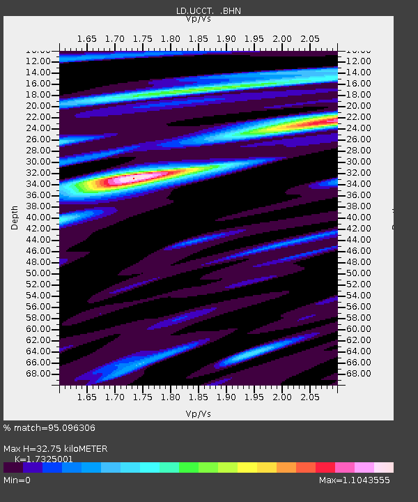
| Estimated Moho Depth: |
32.75 km |
| Estimated Crust Vp/Vs: |
1.73 |
| Assumed Crust Vp: |
6.472 km/s |
| Estimated Crust Vs: |
3.736 km/s |
| Estimated Crust Poisson's Ratio: |
0.25 |
|
| Radial Match: |
95.096306 % |
| Radial Bump: |
358 |
| Transverse Match: |
85.988304 % |
| Transverse Bump: |
400 |
| SOD ConfigId: |
2658 |
| Insert Time: |
2010-03-09 03:12:01.029 +0000 |
| GWidth: |
2.5 |
| Max Bumps: |
400 |
| Tol: |
0.001 |
|

Signal To Noise
| Channel | StoN | STA | LTA |
| LD:UCCT: :BHN:20090306T10:58:20.623989Z | 10.373373 | 2.6724974E-6 | 2.5763052E-7 |
| LD:UCCT: :BHE:20090306T10:58:20.623989Z | 6.0592237 | 1.5736E-6 | 2.5970326E-7 |
| LD:UCCT: :BHZ:20090306T10:58:20.623989Z | 4.5987883 | 9.5153695E-7 | 2.0691034E-7 |
| Arrivals |
| Ps | 4.0 SECOND |
| PpPs | 13 SECOND |
| PsPs/PpSs | 17 SECOND |


