You are here: Home > Network List > LD - Lamont-Doherty Cooperative Seismographic Network Stations List
> Station UCCT University of Connecticut, Storrs, CT > Earthquake Result Viewer
UCCT University of Connecticut, Storrs, CT - Earthquake Result Viewer
| Earthquake location: |
Peru-Brazil Border Region |
| Earthquake latitude/longitude: |
-7.6/-74.4 |
| Earthquake time(UTC): |
2008/08/26 (239) 21:00:36 GMT |
| Earthquake Depth: |
154 km |
| Earthquake Magnitude: |
6.0 MB, 6.4 MW, 6.4 MW |
| Earthquake Catalog/Contributor: |
WHDF/NEIC |
|
| Network: |
LD Lamont-Doherty Cooperative Seismographic Network |
| Station: |
UCCT University of Connecticut, Storrs, CT |
| Lat/Lon: |
41.79 N/72.23 W |
| Elevation: |
200 m |
|
| Distance: |
49.2 deg |
| Az: |
2.124 deg |
| Baz: |
182.816 deg |
| Ray Param: |
0.068297535 |
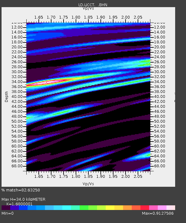
| Estimated Moho Depth: |
34.0 km |
| Estimated Crust Vp/Vs: |
1.68 |
| Assumed Crust Vp: |
6.472 km/s |
| Estimated Crust Vs: |
3.852 km/s |
| Estimated Crust Poisson's Ratio: |
0.23 |
|
| Radial Match: |
82.63258 % |
| Radial Bump: |
400 |
| Transverse Match: |
39.242413 % |
| Transverse Bump: |
400 |
| SOD ConfigId: |
2504 |
| Insert Time: |
2010-03-09 03:12:05.134 +0000 |
| GWidth: |
2.5 |
| Max Bumps: |
400 |
| Tol: |
0.001 |
|

Signal To Noise
| Channel | StoN | STA | LTA |
| LD:UCCT: :BHN:20080826T21:08:38.849014Z | 5.5419784 | 1.2234168E-6 | 2.2075453E-7 |
| LD:UCCT: :BHE:20080826T21:08:38.849014Z | 2.3753116 | 6.672115E-7 | 2.808943E-7 |
| LD:UCCT: :BHZ:20080826T21:08:38.849014Z | 0.30032805 | 1.9938334E-7 | 6.638852E-7 |
| Arrivals |
| Ps | 3.8 SECOND |
| PpPs | 13 SECOND |
| PsPs/PpSs | 17 SECOND |


