You are here: Home > Network List > UU - University of Utah Regional Network Stations List
> Station CCUT Cedar City, UT, USA > Earthquake Result Viewer
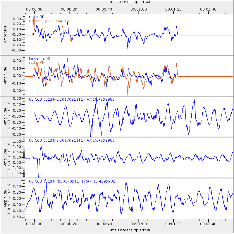
CCUT Cedar City, UT, USA - Earthquake Result Viewer
*The percent match for this event was below the threshold and hence no stack was calculated.
| Earthquake location: |
Volcano Islands, Japan Region |
| Earthquake latitude/longitude: |
24.0/142.3 |
| Earthquake time(UTC): |
2017/09/11 (254) 17:35:09 GMT |
| Earthquake Depth: |
35 km |
| Earthquake Magnitude: |
5.7 Mww |
| Earthquake Catalog/Contributor: |
NEIC PDE/us |
|
| Network: |
UU University of Utah Regional Network |
| Station: |
CCUT Cedar City, UT, USA |
| Lat/Lon: |
37.55 N/113.36 W |
| Elevation: |
2127 m |
|
| Distance: |
86.2 deg |
| Az: |
50.517 deg |
| Baz: |
297.322 deg |
| Ray Param: |
$rayparam |
*The percent match for this event was below the threshold and hence was not used in the summary stack. |
|
| Radial Match: |
55.726658 % |
| Radial Bump: |
370 |
| Transverse Match: |
45.051094 % |
| Transverse Bump: |
400 |
| SOD ConfigId: |
2307692 |
| Insert Time: |
2017-09-25 17:42:51.966 +0000 |
| GWidth: |
2.5 |
| Max Bumps: |
400 |
| Tol: |
0.001 |
|
Signal To Noise
| Channel | StoN | STA | LTA |
| UU:CCUT:01:HHZ:20170911T17:47:16.429998Z | 3.087005 | 6.9450715E-7 | 2.2497765E-7 |
| UU:CCUT:01:HHN:20170911T17:47:16.429998Z | 1.1452897 | 2.507121E-7 | 2.1890718E-7 |
| UU:CCUT:01:HHE:20170911T17:47:16.429998Z | 1.7592807 | 2.7374853E-7 | 1.5560252E-7 |
| Arrivals |
| Ps | |
| PpPs | |
| PsPs/PpSs | |


