You are here: Home > Network List > MY - Malaysian National Seismic Network Stations List
> Station IPM Ipoh > Earthquake Result Viewer
IPM Ipoh - Earthquake Result Viewer
| Earthquake location: |
Solomon Islands |
| Earthquake latitude/longitude: |
-6.9/155.7 |
| Earthquake time(UTC): |
2007/11/20 (324) 12:52:59 GMT |
| Earthquake Depth: |
53 km |
| Earthquake Magnitude: |
5.8 MB, 6.0 MW, 6.0 MW |
| Earthquake Catalog/Contributor: |
WHDF/NEIC |
|
| Network: |
MY Malaysian National Seismic Network |
| Station: |
IPM Ipoh |
| Lat/Lon: |
4.48 N/101.03 E |
| Elevation: |
247 m |
|
| Distance: |
55.7 deg |
| Az: |
280.175 deg |
| Baz: |
101.427 deg |
| Ray Param: |
0.06449207 |
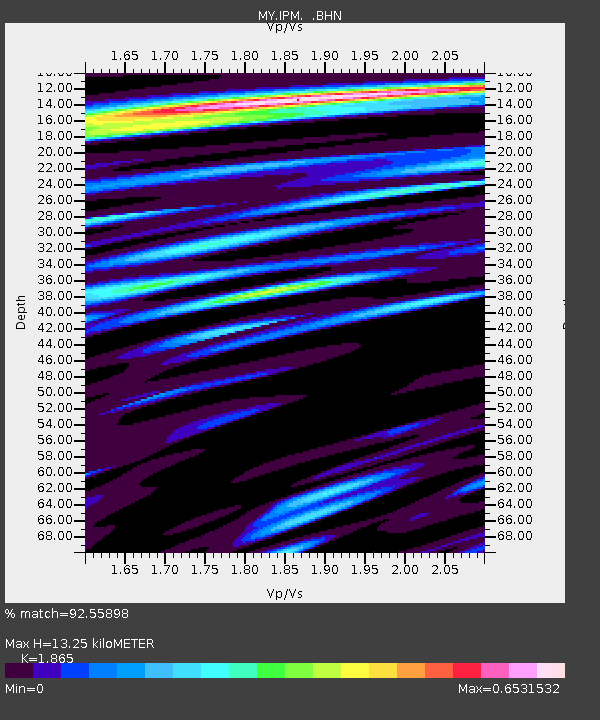
| Estimated Moho Depth: |
13.25 km |
| Estimated Crust Vp/Vs: |
1.87 |
| Assumed Crust Vp: |
6.468 km/s |
| Estimated Crust Vs: |
3.468 km/s |
| Estimated Crust Poisson's Ratio: |
0.30 |
|
| Radial Match: |
92.55898 % |
| Radial Bump: |
400 |
| Transverse Match: |
78.90526 % |
| Transverse Bump: |
400 |
| SOD ConfigId: |
2564 |
| Insert Time: |
2010-03-09 03:14:48.614 +0000 |
| GWidth: |
2.5 |
| Max Bumps: |
400 |
| Tol: |
0.001 |
|

Signal To Noise
| Channel | StoN | STA | LTA |
| MY:IPM: :BHN:20071120T13:01:59.470002Z | 4.364743 | 3.6870256E-7 | 8.44729E-8 |
| MY:IPM: :BHE:20071120T13:01:59.470002Z | 16.78557 | 1.3501691E-6 | 8.0436294E-8 |
| MY:IPM: :BHZ:20071120T13:01:59.470002Z | 26.322767 | 2.8628563E-6 | 1.0875969E-7 |
| Arrivals |
| Ps | 1.9 SECOND |
| PpPs | 5.6 SECOND |
| PsPs/PpSs | 7.4 SECOND |


