You are here: Home > Network List > MY - Malaysian National Seismic Network Stations List
> Station IPM Ipoh > Earthquake Result Viewer
IPM Ipoh - Earthquake Result Viewer
| Earthquake location: |
Solomon Islands |
| Earthquake latitude/longitude: |
-9.8/159.5 |
| Earthquake time(UTC): |
2007/08/16 (228) 08:39:27 GMT |
| Earthquake Depth: |
10 km |
| Earthquake Magnitude: |
6.1 MB, 6.7 MS, 6.4 MW |
| Earthquake Catalog/Contributor: |
WHDF/NEIC |
|
| Network: |
MY Malaysian National Seismic Network |
| Station: |
IPM Ipoh |
| Lat/Lon: |
4.48 N/101.03 E |
| Elevation: |
247 m |
|
| Distance: |
59.9 deg |
| Az: |
280.989 deg |
| Baz: |
103.984 deg |
| Ray Param: |
0.061866432 |
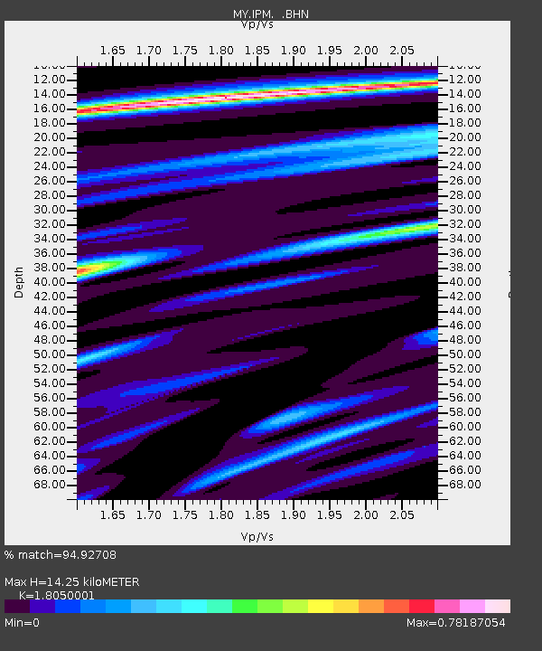
| Estimated Moho Depth: |
14.25 km |
| Estimated Crust Vp/Vs: |
1.81 |
| Assumed Crust Vp: |
6.468 km/s |
| Estimated Crust Vs: |
3.583 km/s |
| Estimated Crust Poisson's Ratio: |
0.28 |
|
| Radial Match: |
94.92708 % |
| Radial Bump: |
335 |
| Transverse Match: |
78.03624 % |
| Transverse Bump: |
400 |
| SOD ConfigId: |
2564 |
| Insert Time: |
2010-03-09 03:15:11.201 +0000 |
| GWidth: |
2.5 |
| Max Bumps: |
400 |
| Tol: |
0.001 |
|

Signal To Noise
| Channel | StoN | STA | LTA |
| MY:IPM: :BHN:20070816T08:49:02.669021Z | 1.0561241 | 1.2526642E-7 | 1.1860958E-7 |
| MY:IPM: :BHE:20070816T08:49:02.669021Z | 1.7788074 | 2.0822365E-7 | 1.1705801E-7 |
| MY:IPM: :BHZ:20070816T08:49:02.669021Z | 2.890568 | 4.1919927E-7 | 1.4502315E-7 |
| Arrivals |
| Ps | 1.9 SECOND |
| PpPs | 5.9 SECOND |
| PsPs/PpSs | 7.8 SECOND |


