You are here: Home > Network List > TA - USArray Transportable Network (new EarthScope stations) Stations List
> Station I30M Mount Dempster, Yukon, CAN > Earthquake Result Viewer
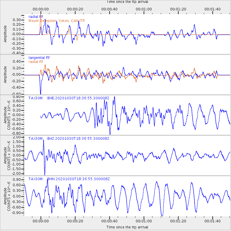
I30M Mount Dempster, Yukon, CAN - Earthquake Result Viewer
*The percent match for this event was below the threshold and hence no stack was calculated.
| Earthquake location: |
Central Peru |
| Earthquake latitude/longitude: |
-10.2/-75.2 |
| Earthquake time(UTC): |
2020/10/30 (304) 18:24:41 GMT |
| Earthquake Depth: |
36 km |
| Earthquake Magnitude: |
5.5 Mww |
| Earthquake Catalog/Contributor: |
NEIC PDE/us |
|
| Network: |
TA USArray Transportable Network (new EarthScope stations) |
| Station: |
I30M Mount Dempster, Yukon, CAN |
| Lat/Lon: |
65.22 N/136.38 W |
| Elevation: |
1399 m |
|
| Distance: |
87.7 deg |
| Az: |
338.309 deg |
| Baz: |
120.296 deg |
| Ray Param: |
$rayparam |
*The percent match for this event was below the threshold and hence was not used in the summary stack. |
|
| Radial Match: |
85.369484 % |
| Radial Bump: |
400 |
| Transverse Match: |
75.16799 % |
| Transverse Bump: |
400 |
| SOD ConfigId: |
23341671 |
| Insert Time: |
2020-11-13 19:44:14.263 +0000 |
| GWidth: |
2.5 |
| Max Bumps: |
400 |
| Tol: |
0.001 |
|
Signal To Noise
| Channel | StoN | STA | LTA |
| TA:I30M: :BHZ:20201030T18:36:55.300008Z | 3.8995771 | 7.948174E-7 | 2.0382144E-7 |
| TA:I30M: :BHN:20201030T18:36:55.300008Z | 1.3282869 | 4.3024505E-7 | 3.2390975E-7 |
| TA:I30M: :BHE:20201030T18:36:55.300008Z | 2.4945602 | 2.885207E-7 | 1.1565996E-7 |
| Arrivals |
| Ps | |
| PpPs | |
| PsPs/PpSs | |


