You are here: Home > Network List > GS - US Geological Survey Networks Stations List
> Station MT03 Stemple Pass Rd, Helena Natl Forest, Montana, USA > Earthquake Result Viewer
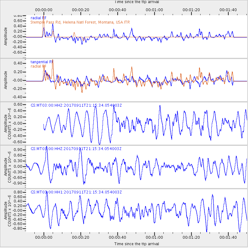
MT03 Stemple Pass Rd, Helena Natl Forest, Montana, USA - Earthquake Result Viewer
*The percent match for this event was below the threshold and hence no stack was calculated.
| Earthquake location: |
Near Coast Of Chiapas, Mexico |
| Earthquake latitude/longitude: |
14.9/-93.9 |
| Earthquake time(UTC): |
2017/09/11 (254) 21:09:10 GMT |
| Earthquake Depth: |
27 km |
| Earthquake Magnitude: |
5.5 Mww |
| Earthquake Catalog/Contributor: |
NEIC PDE/us |
|
| Network: |
GS US Geological Survey Networks |
| Station: |
MT03 Stemple Pass Rd, Helena Natl Forest, Montana, USA |
| Lat/Lon: |
46.91 N/112.50 W |
| Elevation: |
2025 m |
|
| Distance: |
35.5 deg |
| Az: |
337.938 deg |
| Baz: |
148.008 deg |
| Ray Param: |
$rayparam |
*The percent match for this event was below the threshold and hence was not used in the summary stack. |
|
| Radial Match: |
65.15186 % |
| Radial Bump: |
400 |
| Transverse Match: |
48.74719 % |
| Transverse Bump: |
400 |
| SOD ConfigId: |
2307692 |
| Insert Time: |
2017-09-25 21:11:17.410 +0000 |
| GWidth: |
2.5 |
| Max Bumps: |
400 |
| Tol: |
0.001 |
|
Signal To Noise
| Channel | StoN | STA | LTA |
| GS:MT03:00:HHZ:20170911T21:15:34.054003Z | 2.6213465 | 5.744183E-7 | 2.1913102E-7 |
| GS:MT03:00:HH1:20170911T21:15:34.054003Z | 1.8224106 | 4.6468801E-7 | 2.5498537E-7 |
| GS:MT03:00:HH2:20170911T21:15:34.054003Z | 1.739652 | 4.0439252E-7 | 2.3245599E-7 |
| Arrivals |
| Ps | |
| PpPs | |
| PsPs/PpSs | |


