You are here: Home > Network List > TX - Texas Seismological Network Stations List
> Station WTFS Witchita Falls > Earthquake Result Viewer
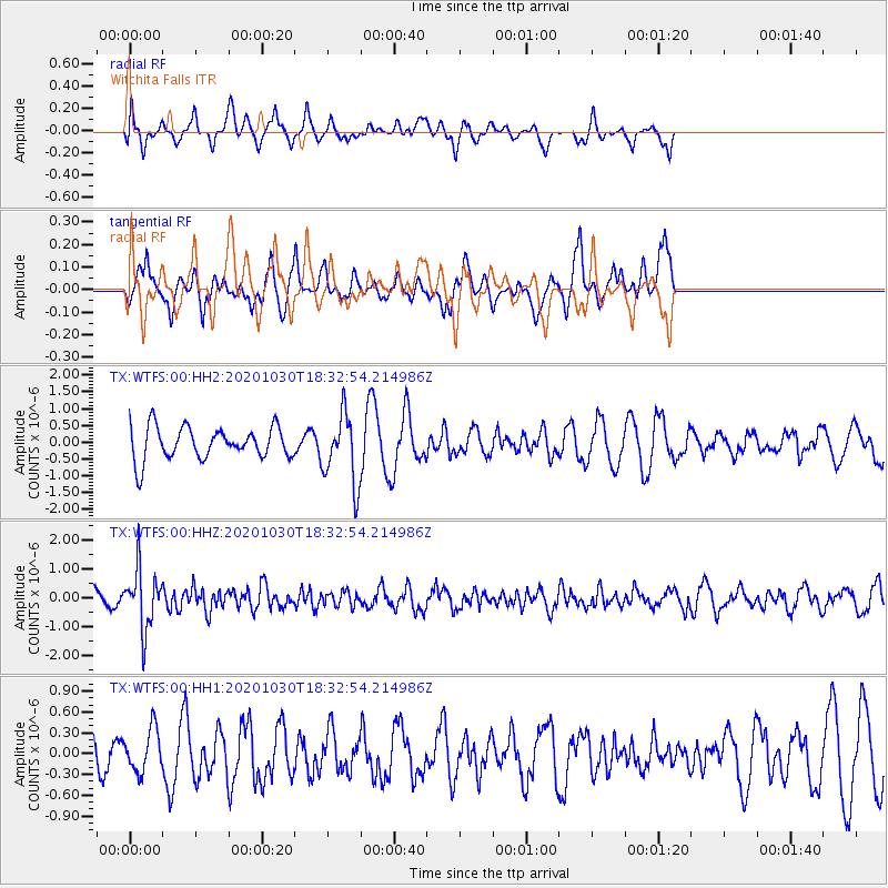
WTFS Witchita Falls - Earthquake Result Viewer
*The percent match for this event was below the threshold and hence no stack was calculated.
| Earthquake location: |
Central Peru |
| Earthquake latitude/longitude: |
-10.2/-75.2 |
| Earthquake time(UTC): |
2020/10/30 (304) 18:24:41 GMT |
| Earthquake Depth: |
36 km |
| Earthquake Magnitude: |
5.5 Mww |
| Earthquake Catalog/Contributor: |
NEIC PDE/us |
|
| Network: |
TX Texas Seismological Network |
| Station: |
WTFS Witchita Falls |
| Lat/Lon: |
33.77 N/98.46 W |
| Elevation: |
277 m |
|
| Distance: |
49.0 deg |
| Az: |
334.122 deg |
| Baz: |
148.948 deg |
| Ray Param: |
$rayparam |
*The percent match for this event was below the threshold and hence was not used in the summary stack. |
|
| Radial Match: |
33.92292 % |
| Radial Bump: |
284 |
| Transverse Match: |
54.704872 % |
| Transverse Bump: |
328 |
| SOD ConfigId: |
23341671 |
| Insert Time: |
2020-11-13 19:46:02.953 +0000 |
| GWidth: |
2.5 |
| Max Bumps: |
400 |
| Tol: |
0.001 |
|
Signal To Noise
| Channel | StoN | STA | LTA |
| TX:WTFS:00:HHZ:20201030T18:32:54.214986Z | 3.1228452 | 1.0329601E-6 | 3.307753E-7 |
| TX:WTFS:00:HH1:20201030T18:32:54.214986Z | 0.71617067 | 3.0493726E-7 | 4.2578853E-7 |
| TX:WTFS:00:HH2:20201030T18:32:54.214986Z | 2.1558871 | 1.0321643E-6 | 4.7876546E-7 |
| Arrivals |
| Ps | |
| PpPs | |
| PsPs/PpSs | |


