You are here: Home > Network List > US - United States National Seismic Network Stations List
> Station MSO Missoula, Montana, USA > Earthquake Result Viewer
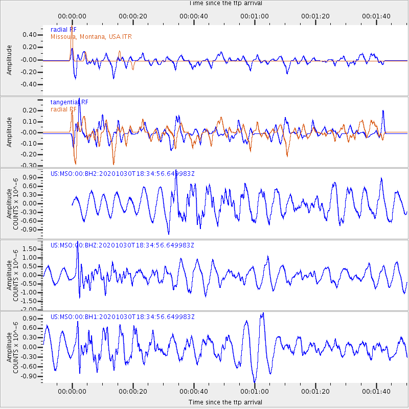
MSO Missoula, Montana, USA - Earthquake Result Viewer
*The percent match for this event was below the threshold and hence no stack was calculated.
| Earthquake location: |
Central Peru |
| Earthquake latitude/longitude: |
-10.2/-75.2 |
| Earthquake time(UTC): |
2020/10/30 (304) 18:24:41 GMT |
| Earthquake Depth: |
36 km |
| Earthquake Magnitude: |
5.5 Mww |
| Earthquake Catalog/Contributor: |
NEIC PDE/us |
|
| Network: |
US United States National Seismic Network |
| Station: |
MSO Missoula, Montana, USA |
| Lat/Lon: |
46.83 N/113.94 W |
| Elevation: |
1264 m |
|
| Distance: |
66.5 deg |
| Az: |
332.034 deg |
| Baz: |
137.749 deg |
| Ray Param: |
$rayparam |
*The percent match for this event was below the threshold and hence was not used in the summary stack. |
|
| Radial Match: |
58.28529 % |
| Radial Bump: |
400 |
| Transverse Match: |
36.7408 % |
| Transverse Bump: |
400 |
| SOD ConfigId: |
23341671 |
| Insert Time: |
2020-11-13 19:47:10.995 +0000 |
| GWidth: |
2.5 |
| Max Bumps: |
400 |
| Tol: |
0.001 |
|
Signal To Noise
| Channel | StoN | STA | LTA |
| US:MSO:00:BHZ:20201030T18:34:56.649983Z | 2.2477055 | 6.584383E-7 | 2.9293798E-7 |
| US:MSO:00:BH1:20201030T18:34:56.649983Z | 0.9094107 | 3.3128615E-7 | 3.642866E-7 |
| US:MSO:00:BH2:20201030T18:34:56.649983Z | 1.9932688 | 5.631312E-7 | 2.8251642E-7 |
| Arrivals |
| Ps | |
| PpPs | |
| PsPs/PpSs | |


