You are here: Home > Network List > UU - University of Utah Regional Network Stations List
> Station FORU South Mineral Mountains, UT, USA > Earthquake Result Viewer
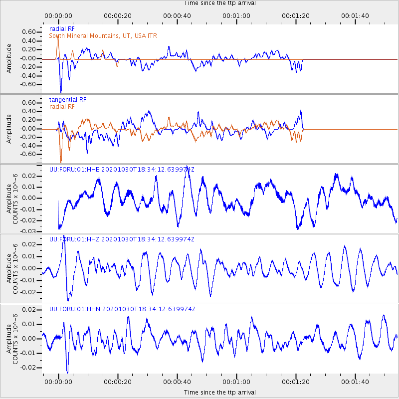
FORU South Mineral Mountains, UT, USA - Earthquake Result Viewer
*The percent match for this event was below the threshold and hence no stack was calculated.
| Earthquake location: |
Central Peru |
| Earthquake latitude/longitude: |
-10.2/-75.2 |
| Earthquake time(UTC): |
2020/10/30 (304) 18:24:41 GMT |
| Earthquake Depth: |
36 km |
| Earthquake Magnitude: |
5.5 Mww |
| Earthquake Catalog/Contributor: |
NEIC PDE/us |
|
| Network: |
UU University of Utah Regional Network |
| Station: |
FORU South Mineral Mountains, UT, USA |
| Lat/Lon: |
38.46 N/112.86 W |
| Elevation: |
1840 m |
|
| Distance: |
59.8 deg |
| Az: |
326.269 deg |
| Baz: |
135.868 deg |
| Ray Param: |
$rayparam |
*The percent match for this event was below the threshold and hence was not used in the summary stack. |
|
| Radial Match: |
55.497963 % |
| Radial Bump: |
400 |
| Transverse Match: |
66.545685 % |
| Transverse Bump: |
400 |
| SOD ConfigId: |
23341671 |
| Insert Time: |
2020-11-13 19:47:37.538 +0000 |
| GWidth: |
2.5 |
| Max Bumps: |
400 |
| Tol: |
0.001 |
|
Signal To Noise
| Channel | StoN | STA | LTA |
| UU:FORU:01:HHZ:20201030T18:34:12.639974Z | 3.0950415 | 1.685586E-8 | 5.446086E-9 |
| UU:FORU:01:HHN:20201030T18:34:12.639974Z | 1.0258222 | 9.088251E-9 | 8.85948E-9 |
| UU:FORU:01:HHE:20201030T18:34:12.639974Z | 0.8516709 | 8.685319E-9 | 1.0197976E-8 |
| Arrivals |
| Ps | |
| PpPs | |
| PsPs/PpSs | |


