You are here: Home > Network List > MY - Malaysian National Seismic Network Stations List
> Station IPM Ipoh > Earthquake Result Viewer
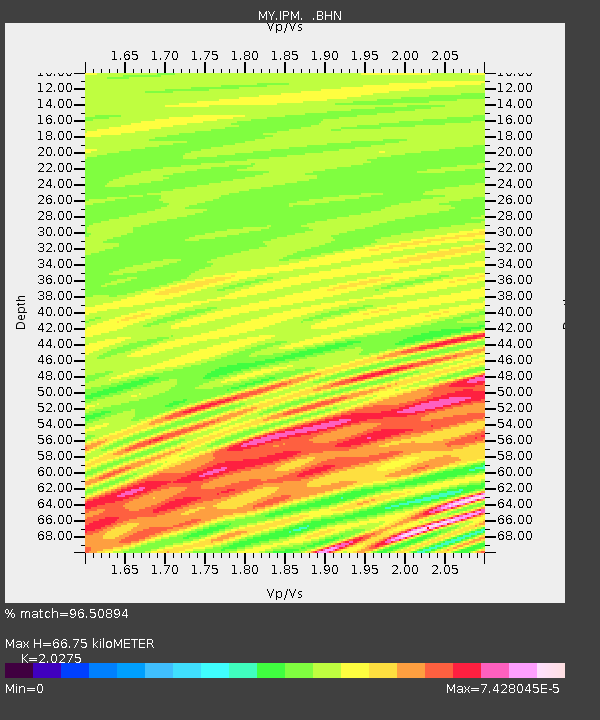
IPM Ipoh - Earthquake Result Viewer
| Earthquake location: |
Solomon Islands |
| Earthquake latitude/longitude: |
-7.3/155.6 |
| Earthquake time(UTC): |
2007/04/01 (091) 21:45:37 GMT |
| Earthquake Depth: |
10 km |
| Earthquake Magnitude: |
5.7 MB |
| Earthquake Catalog/Contributor: |
WHDF/NEIC |
|
| Network: |
MY Malaysian National Seismic Network |
| Station: |
IPM Ipoh |
| Lat/Lon: |
4.48 N/101.03 E |
| Elevation: |
247 m |
|
| Distance: |
55.8 deg |
| Az: |
280.462 deg |
| Baz: |
101.931 deg |
| Ray Param: |
0.06458869 |
| Estimated Moho Depth: |
66.75 km |
| Estimated Crust Vp/Vs: |
2.03 |
| Assumed Crust Vp: |
6.468 km/s |
| Estimated Crust Vs: |
3.19 km/s |
| Estimated Crust Poisson's Ratio: |
0.34 |
|
| Radial Match: |
96.50894 % |
| Radial Bump: |
158 |
| Transverse Match: |
99.28745 % |
| Transverse Bump: |
46 |
| SOD ConfigId: |
2564 |
| Insert Time: |
2010-03-09 03:15:51.773 +0000 |
| GWidth: |
2.5 |
| Max Bumps: |
400 |
| Tol: |
0.001 |
|

Signal To Noise
| Channel | StoN | STA | LTA |
| MY:IPM: :BHN:20070401T21:54:43.420007Z | 0.93975264 | 7.700343E-10 | 8.1940105E-10 |
| MY:IPM: :BHE:20070401T21:54:43.420007Z | 1.065632 | 1.0534277E-9 | 9.885474E-10 |
| MY:IPM: :BHZ:20070401T21:54:43.420007Z | 0.8703031 | 2.980516E-8 | 3.4246874E-8 |
| Arrivals |
| Ps | 11 SECOND |
| PpPs | 30 SECOND |
| PsPs/PpSs | 41 SECOND |


