You are here: Home > Network List > IW - Intermountain West Stations List
> Station IMW Indian Meadow, Wyoming, USA > Earthquake Result Viewer
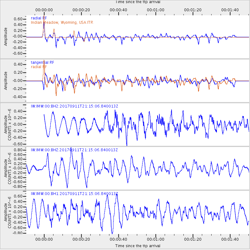
IMW Indian Meadow, Wyoming, USA - Earthquake Result Viewer
*The percent match for this event was below the threshold and hence no stack was calculated.
| Earthquake location: |
Near Coast Of Chiapas, Mexico |
| Earthquake latitude/longitude: |
14.9/-93.9 |
| Earthquake time(UTC): |
2017/09/11 (254) 21:09:10 GMT |
| Earthquake Depth: |
27 km |
| Earthquake Magnitude: |
5.5 Mww |
| Earthquake Catalog/Contributor: |
NEIC PDE/us |
|
| Network: |
IW Intermountain West |
| Station: |
IMW Indian Meadow, Wyoming, USA |
| Lat/Lon: |
43.90 N/110.94 W |
| Elevation: |
2646 m |
|
| Distance: |
32.4 deg |
| Az: |
336.75 deg |
| Baz: |
148.129 deg |
| Ray Param: |
$rayparam |
*The percent match for this event was below the threshold and hence was not used in the summary stack. |
|
| Radial Match: |
49.846394 % |
| Radial Bump: |
337 |
| Transverse Match: |
48.924885 % |
| Transverse Bump: |
400 |
| SOD ConfigId: |
2307692 |
| Insert Time: |
2017-09-25 21:12:02.949 +0000 |
| GWidth: |
2.5 |
| Max Bumps: |
400 |
| Tol: |
0.001 |
|
Signal To Noise
| Channel | StoN | STA | LTA |
| IW:IMW:00:BHZ:20170911T21:15:06.840013Z | 2.087949 | 3.784219E-7 | 1.8124098E-7 |
| IW:IMW:00:BH1:20170911T21:15:06.840013Z | 0.8327146 | 2.714898E-7 | 3.260298E-7 |
| IW:IMW:00:BH2:20170911T21:15:06.840013Z | 1.0199318 | 2.075068E-7 | 2.0345163E-7 |
| Arrivals |
| Ps | |
| PpPs | |
| PsPs/PpSs | |


