You are here: Home > Network List > TA - USArray Transportable Network (new EarthScope stations) Stations List
> Station POKR Poker Plat Research Range, AK, USA > Earthquake Result Viewer
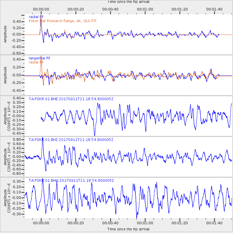
POKR Poker Plat Research Range, AK, USA - Earthquake Result Viewer
*The percent match for this event was below the threshold and hence no stack was calculated.
| Earthquake location: |
Near Coast Of Chiapas, Mexico |
| Earthquake latitude/longitude: |
14.9/-93.9 |
| Earthquake time(UTC): |
2017/09/11 (254) 21:09:10 GMT |
| Earthquake Depth: |
27 km |
| Earthquake Magnitude: |
5.5 Mww |
| Earthquake Catalog/Contributor: |
NEIC PDE/us |
|
| Network: |
TA USArray Transportable Network (new EarthScope stations) |
| Station: |
POKR Poker Plat Research Range, AK, USA |
| Lat/Lon: |
65.12 N/147.43 W |
| Elevation: |
501 m |
|
| Distance: |
61.7 deg |
| Az: |
337.275 deg |
| Baz: |
118.008 deg |
| Ray Param: |
$rayparam |
*The percent match for this event was below the threshold and hence was not used in the summary stack. |
|
| Radial Match: |
68.4867 % |
| Radial Bump: |
377 |
| Transverse Match: |
63.208797 % |
| Transverse Bump: |
400 |
| SOD ConfigId: |
2307692 |
| Insert Time: |
2017-09-25 21:12:40.246 +0000 |
| GWidth: |
2.5 |
| Max Bumps: |
400 |
| Tol: |
0.001 |
|
Signal To Noise
| Channel | StoN | STA | LTA |
| TA:POKR:01:BHZ:20170911T21:18:54.800005Z | 3.781223 | 3.7059314E-7 | 9.8008805E-8 |
| TA:POKR:01:BHN:20170911T21:18:54.800005Z | 1.2396038 | 1.698051E-7 | 1.3698337E-7 |
| TA:POKR:01:BHE:20170911T21:18:54.800005Z | 2.7298133 | 2.1767006E-7 | 7.973808E-8 |
| Arrivals |
| Ps | |
| PpPs | |
| PsPs/PpSs | |


