You are here: Home > Network List > US - United States National Seismic Network Stations List
> Station MIAR Mount Ida, Arkansas, USA > Earthquake Result Viewer
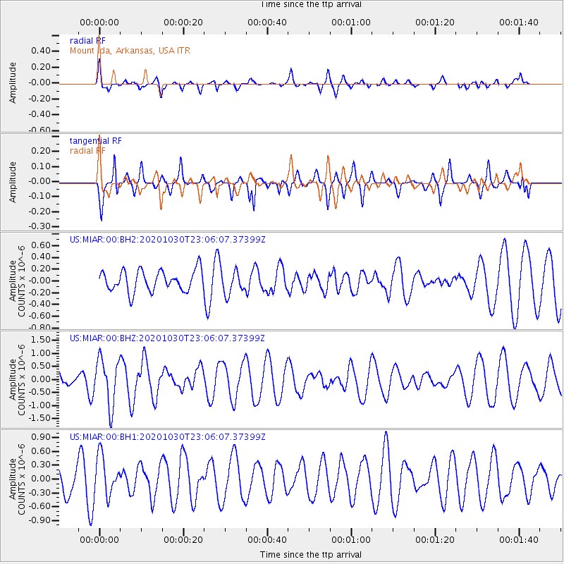
MIAR Mount Ida, Arkansas, USA - Earthquake Result Viewer
*The percent match for this event was below the threshold and hence no stack was calculated.
| Earthquake location: |
Jan Mayen Island Region |
| Earthquake latitude/longitude: |
71.6/-3.3 |
| Earthquake time(UTC): |
2020/10/30 (304) 22:56:47 GMT |
| Earthquake Depth: |
10 km |
| Earthquake Magnitude: |
5.6 mww |
| Earthquake Catalog/Contributor: |
NEIC PDE/us |
|
| Network: |
US United States National Seismic Network |
| Station: |
MIAR Mount Ida, Arkansas, USA |
| Lat/Lon: |
34.55 N/93.58 W |
| Elevation: |
207 m |
|
| Distance: |
57.7 deg |
| Az: |
282.487 deg |
| Baz: |
22.108 deg |
| Ray Param: |
$rayparam |
*The percent match for this event was below the threshold and hence was not used in the summary stack. |
|
| Radial Match: |
43.279533 % |
| Radial Bump: |
372 |
| Transverse Match: |
49.51845 % |
| Transverse Bump: |
294 |
| SOD ConfigId: |
23341671 |
| Insert Time: |
2020-11-14 00:15:37.962 +0000 |
| GWidth: |
2.5 |
| Max Bumps: |
400 |
| Tol: |
0.001 |
|
Signal To Noise
| Channel | StoN | STA | LTA |
| US:MIAR:00:BHZ:20201030T23:06:07.37399Z | 2.8469458 | 9.2869504E-7 | 3.2620747E-7 |
| US:MIAR:00:BH1:20201030T23:06:07.37399Z | 0.85613894 | 4.3005048E-7 | 5.0231387E-7 |
| US:MIAR:00:BH2:20201030T23:06:07.37399Z | 1.112605 | 1.9514123E-7 | 1.7539129E-7 |
| Arrivals |
| Ps | |
| PpPs | |
| PsPs/PpSs | |


