You are here: Home > Network List > MY - Malaysian National Seismic Network Stations List
> Station IPM Ipoh > Earthquake Result Viewer
IPM Ipoh - Earthquake Result Viewer
| Earthquake location: |
Banda Sea |
| Earthquake latitude/longitude: |
-6.1/130.4 |
| Earthquake time(UTC): |
2009/10/24 (297) 14:40:43 GMT |
| Earthquake Depth: |
130 km |
| Earthquake Magnitude: |
6.7 MB, 6.9 MW, 6.9 MW |
| Earthquake Catalog/Contributor: |
WHDF/NEIC |
|
| Network: |
MY Malaysian National Seismic Network |
| Station: |
IPM Ipoh |
| Lat/Lon: |
4.48 N/101.03 E |
| Elevation: |
247 m |
|
| Distance: |
31.2 deg |
| Az: |
289.11 deg |
| Baz: |
109.542 deg |
| Ray Param: |
0.07883515 |
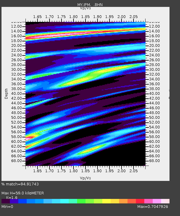
| Estimated Moho Depth: |
59.0 km |
| Estimated Crust Vp/Vs: |
1.60 |
| Assumed Crust Vp: |
6.468 km/s |
| Estimated Crust Vs: |
4.042 km/s |
| Estimated Crust Poisson's Ratio: |
0.18 |
|
| Radial Match: |
94.91743 % |
| Radial Bump: |
293 |
| Transverse Match: |
72.7074 % |
| Transverse Bump: |
400 |
| SOD ConfigId: |
2622 |
| Insert Time: |
2010-03-09 03:16:53.760 +0000 |
| GWidth: |
2.5 |
| Max Bumps: |
400 |
| Tol: |
0.001 |
|

Signal To Noise
| Channel | StoN | STA | LTA |
| MY:IPM: :BHN:20091024T14:46:20.019011Z | 49.702374 | 5.748793E-6 | 1.15664356E-7 |
| MY:IPM: :BHE:20091024T14:46:20.019011Z | 19.974606 | 1.0045138E-6 | 5.0289547E-8 |
| MY:IPM: :BHZ:20091024T14:46:20.019011Z | 39.98615 | 3.0795773E-6 | 7.70161E-8 |
| Arrivals |
| Ps | 6.0 SECOND |
| PpPs | 22 SECOND |
| PsPs/PpSs | 28 SECOND |


