You are here: Home > Network List > CI - Caltech Regional Seismic Network Stations List
> Station MUR Murrieta > Earthquake Result Viewer
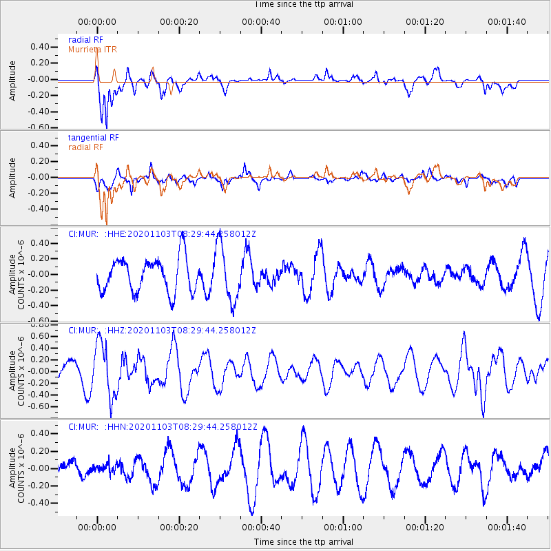
MUR Murrieta - Earthquake Result Viewer
*The percent match for this event was below the threshold and hence no stack was calculated.
| Earthquake location: |
Fiji Islands Region |
| Earthquake latitude/longitude: |
-20.0/-177.5 |
| Earthquake time(UTC): |
2020/11/03 (308) 08:18:56 GMT |
| Earthquake Depth: |
388 km |
| Earthquake Magnitude: |
5.7 mww |
| Earthquake Catalog/Contributor: |
NEIC PDE/us |
|
| Network: |
CI Caltech Regional Seismic Network |
| Station: |
MUR Murrieta |
| Lat/Lon: |
33.60 N/117.20 W |
| Elevation: |
562 m |
|
| Distance: |
78.4 deg |
| Az: |
47.743 deg |
| Baz: |
236.504 deg |
| Ray Param: |
$rayparam |
*The percent match for this event was below the threshold and hence was not used in the summary stack. |
|
| Radial Match: |
70.07074 % |
| Radial Bump: |
400 |
| Transverse Match: |
55.978287 % |
| Transverse Bump: |
343 |
| SOD ConfigId: |
23341671 |
| Insert Time: |
2020-11-17 09:25:54.905 +0000 |
| GWidth: |
2.5 |
| Max Bumps: |
400 |
| Tol: |
0.001 |
|
Signal To Noise
| Channel | StoN | STA | LTA |
| CI:MUR: :HHZ:20201103T08:29:44.258012Z | 2.9554513 | 4.6998704E-7 | 1.5902378E-7 |
| CI:MUR: :HHN:20201103T08:29:44.258012Z | 0.27932662 | 4.7473637E-8 | 1.6995745E-7 |
| CI:MUR: :HHE:20201103T08:29:44.258012Z | 1.6812282 | 3.6271965E-7 | 2.1574684E-7 |
| Arrivals |
| Ps | |
| PpPs | |
| PsPs/PpSs | |


