You are here: Home > Network List > TA - USArray Transportable Network (new EarthScope stations) Stations List
> Station E20K Nigu River, AK, USA > Earthquake Result Viewer
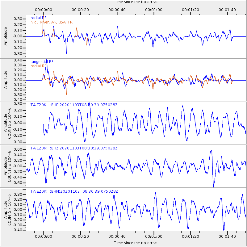
E20K Nigu River, AK, USA - Earthquake Result Viewer
*The percent match for this event was below the threshold and hence no stack was calculated.
| Earthquake location: |
Fiji Islands Region |
| Earthquake latitude/longitude: |
-20.0/-177.5 |
| Earthquake time(UTC): |
2020/11/03 (308) 08:18:56 GMT |
| Earthquake Depth: |
388 km |
| Earthquake Magnitude: |
5.7 mww |
| Earthquake Catalog/Contributor: |
NEIC PDE/us |
|
| Network: |
TA USArray Transportable Network (new EarthScope stations) |
| Station: |
E20K Nigu River, AK, USA |
| Lat/Lon: |
68.26 N/156.19 W |
| Elevation: |
866 m |
|
| Distance: |
89.4 deg |
| Az: |
7.778 deg |
| Baz: |
199.975 deg |
| Ray Param: |
$rayparam |
*The percent match for this event was below the threshold and hence was not used in the summary stack. |
|
| Radial Match: |
53.402626 % |
| Radial Bump: |
380 |
| Transverse Match: |
56.90041 % |
| Transverse Bump: |
400 |
| SOD ConfigId: |
23341671 |
| Insert Time: |
2020-11-17 09:32:35.215 +0000 |
| GWidth: |
2.5 |
| Max Bumps: |
400 |
| Tol: |
0.001 |
|
Signal To Noise
| Channel | StoN | STA | LTA |
| TA:E20K: :BHZ:20201103T08:30:39.075028Z | 2.1878507 | 3.0760722E-7 | 1.4059789E-7 |
| TA:E20K: :BHN:20201103T08:30:39.075028Z | 1.0468136 | 1.3688567E-7 | 1.3076412E-7 |
| TA:E20K: :BHE:20201103T08:30:39.075028Z | 0.7814395 | 1.0226547E-7 | 1.3086806E-7 |
| Arrivals |
| Ps | |
| PpPs | |
| PsPs/PpSs | |


