You are here: Home > Network List > IU - Global Seismograph Network (GSN - IRIS/USGS) Stations List
> Station XMAS Kiritimati Island, Republic of Kiribati > Earthquake Result Viewer
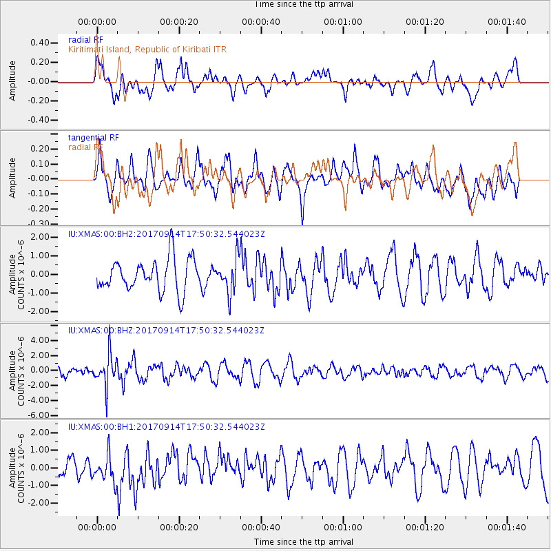
XMAS Kiritimati Island, Republic of Kiribati - Earthquake Result Viewer
*The percent match for this event was below the threshold and hence no stack was calculated.
| Earthquake location: |
Mariana Islands |
| Earthquake latitude/longitude: |
18.7/145.7 |
| Earthquake time(UTC): |
2017/09/14 (257) 17:41:28 GMT |
| Earthquake Depth: |
173 km |
| Earthquake Magnitude: |
5.8 mww |
| Earthquake Catalog/Contributor: |
NEIC PDE/us |
|
| Network: |
IU Global Seismograph Network (GSN - IRIS/USGS) |
| Station: |
XMAS Kiritimati Island, Republic of Kiribati |
| Lat/Lon: |
2.04 N/157.45 W |
| Elevation: |
20 m |
|
| Distance: |
58.0 deg |
| Az: |
99.529 deg |
| Baz: |
290.686 deg |
| Ray Param: |
$rayparam |
*The percent match for this event was below the threshold and hence was not used in the summary stack. |
|
| Radial Match: |
60.871426 % |
| Radial Bump: |
400 |
| Transverse Match: |
61.290302 % |
| Transverse Bump: |
400 |
| SOD ConfigId: |
2307692 |
| Insert Time: |
2017-09-28 17:45:46.814 +0000 |
| GWidth: |
2.5 |
| Max Bumps: |
400 |
| Tol: |
0.001 |
|
Signal To Noise
| Channel | StoN | STA | LTA |
| IU:XMAS:00:BHZ:20170914T17:50:32.544023Z | 4.268362 | 2.2345223E-6 | 5.235082E-7 |
| IU:XMAS:00:BH1:20170914T17:50:32.544023Z | 1.1905084 | 8.3477585E-7 | 7.0119273E-7 |
| IU:XMAS:00:BH2:20170914T17:50:32.544023Z | 1.0905614 | 9.4675227E-7 | 8.6813293E-7 |
| Arrivals |
| Ps | |
| PpPs | |
| PsPs/PpSs | |


