You are here: Home > Network List > US - United States National Seismic Network Stations List
> Station MSO Missoula, Montana, USA > Earthquake Result Viewer
MSO Missoula, Montana, USA - Earthquake Result Viewer
*The percent match for this event was below the threshold and hence no stack was calculated.
| Earthquake location: |
Mariana Islands |
| Earthquake latitude/longitude: |
18.7/145.7 |
| Earthquake time(UTC): |
2017/09/14 (257) 17:41:28 GMT |
| Earthquake Depth: |
173 km |
| Earthquake Magnitude: |
5.8 mww |
| Earthquake Catalog/Contributor: |
NEIC PDE/us |
|
| Network: |
US United States National Seismic Network |
| Station: |
MSO Missoula, Montana, USA |
| Lat/Lon: |
46.83 N/113.94 W |
| Elevation: |
1264 m |
|
| Distance: |
83.4 deg |
| Az: |
42.842 deg |
| Baz: |
290.139 deg |
| Ray Param: |
$rayparam |
*The percent match for this event was below the threshold and hence was not used in the summary stack. |
|
| Radial Match: |
43.0073 % |
| Radial Bump: |
400 |
| Transverse Match: |
37.46764 % |
| Transverse Bump: |
400 |
| SOD ConfigId: |
2307692 |
| Insert Time: |
2017-09-28 17:47:05.785 +0000 |
| GWidth: |
2.5 |
| Max Bumps: |
400 |
| Tol: |
0.001 |
|
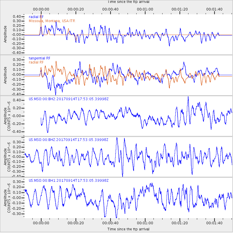
Signal To Noise
| Channel | StoN | STA | LTA |
| US:MSO:00:BHZ:20170914T17:53:05.39998Z | 2.3460634 | 1.4642275E-7 | 6.24121E-8 |
| US:MSO:00:BH1:20170914T17:53:05.39998Z | 1.4759011 | 1.6284174E-7 | 1.1033377E-7 |
| US:MSO:00:BH2:20170914T17:53:05.39998Z | 0.9382653 | 1.1467102E-7 | 1.2221598E-7 |
| Arrivals |
| Ps | |
| PpPs | |
| PsPs/PpSs | |


