You are here: Home > Network List > AK - Alaska Regional Network Stations List
> Station D25K Kavik River, AK, USA > Earthquake Result Viewer
D25K Kavik River, AK, USA - Earthquake Result Viewer
| Earthquake location: |
Volcano Islands, Japan Region |
| Earthquake latitude/longitude: |
25.7/143.6 |
| Earthquake time(UTC): |
2020/11/07 (312) 01:10:32 GMT |
| Earthquake Depth: |
18 km |
| Earthquake Magnitude: |
5.8 mww |
| Earthquake Catalog/Contributor: |
NEIC PDE/us |
|
| Network: |
AK Alaska Regional Network |
| Station: |
D25K Kavik River, AK, USA |
| Lat/Lon: |
69.32 N/146.38 W |
| Elevation: |
770 m |
|
| Distance: |
59.2 deg |
| Az: |
22.876 deg |
| Baz: |
260.928 deg |
| Ray Param: |
0.062358744 |
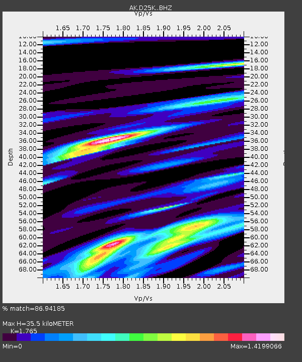
| Estimated Moho Depth: |
35.5 km |
| Estimated Crust Vp/Vs: |
1.76 |
| Assumed Crust Vp: |
6.378 km/s |
| Estimated Crust Vs: |
3.614 km/s |
| Estimated Crust Poisson's Ratio: |
0.26 |
|
| Radial Match: |
86.94185 % |
| Radial Bump: |
400 |
| Transverse Match: |
72.986046 % |
| Transverse Bump: |
400 |
| SOD ConfigId: |
23341671 |
| Insert Time: |
2020-11-21 02:14:32.177 +0000 |
| GWidth: |
2.5 |
| Max Bumps: |
400 |
| Tol: |
0.001 |
|

Signal To Noise
| Channel | StoN | STA | LTA |
| AK:D25K: :BHZ:20201107T01:20:00.760008Z | 5.4385877 | 1.0450085E-6 | 1.9214703E-7 |
| AK:D25K: :BHN:20201107T01:20:00.760008Z | 1.7283889 | 2.9109432E-7 | 1.6841946E-7 |
| AK:D25K: :BHE:20201107T01:20:00.760008Z | 3.7236183 | 5.6604324E-7 | 1.520143E-7 |
| Arrivals |
| Ps | 4.5 SECOND |
| PpPs | 15 SECOND |
| PsPs/PpSs | 19 SECOND |


