You are here: Home > Network List > TA - USArray Transportable Network (new EarthScope stations) Stations List
> Station E20K Nigu River, AK, USA > Earthquake Result Viewer
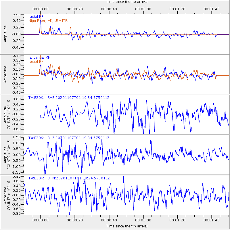
E20K Nigu River, AK, USA - Earthquake Result Viewer
*The percent match for this event was below the threshold and hence no stack was calculated.
| Earthquake location: |
Volcano Islands, Japan Region |
| Earthquake latitude/longitude: |
25.7/143.6 |
| Earthquake time(UTC): |
2020/11/07 (312) 01:10:32 GMT |
| Earthquake Depth: |
18 km |
| Earthquake Magnitude: |
5.8 mww |
| Earthquake Catalog/Contributor: |
NEIC PDE/us |
|
| Network: |
TA USArray Transportable Network (new EarthScope stations) |
| Station: |
E20K Nigu River, AK, USA |
| Lat/Lon: |
68.26 N/156.19 W |
| Elevation: |
866 m |
|
| Distance: |
55.4 deg |
| Az: |
23.112 deg |
| Baz: |
251.912 deg |
| Ray Param: |
$rayparam |
*The percent match for this event was below the threshold and hence was not used in the summary stack. |
|
| Radial Match: |
68.868515 % |
| Radial Bump: |
400 |
| Transverse Match: |
61.744934 % |
| Transverse Bump: |
400 |
| SOD ConfigId: |
23341671 |
| Insert Time: |
2020-11-21 02:27:40.854 +0000 |
| GWidth: |
2.5 |
| Max Bumps: |
400 |
| Tol: |
0.001 |
|
Signal To Noise
| Channel | StoN | STA | LTA |
| TA:E20K: :BHZ:20201107T01:19:34.575011Z | 3.2058709 | 8.53661E-7 | 2.6628052E-7 |
| TA:E20K: :BHN:20201107T01:19:34.575011Z | 1.1099195 | 2.2319264E-7 | 2.0108902E-7 |
| TA:E20K: :BHE:20201107T01:19:34.575011Z | 1.5168602 | 3.0126373E-7 | 1.9861005E-7 |
| Arrivals |
| Ps | |
| PpPs | |
| PsPs/PpSs | |


