You are here: Home > Network List > TA - USArray Transportable Network (new EarthScope stations) Stations List
> Station F26K Sheenjek River, AK, USA > Earthquake Result Viewer
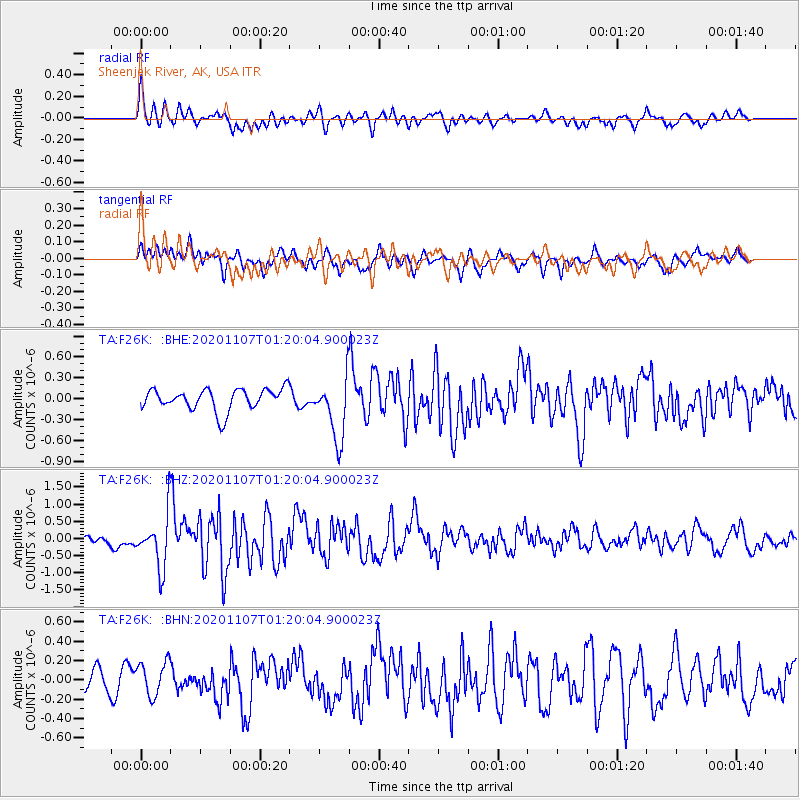
F26K Sheenjek River, AK, USA - Earthquake Result Viewer
*The percent match for this event was below the threshold and hence no stack was calculated.
| Earthquake location: |
Volcano Islands, Japan Region |
| Earthquake latitude/longitude: |
25.7/143.6 |
| Earthquake time(UTC): |
2020/11/07 (312) 01:10:32 GMT |
| Earthquake Depth: |
18 km |
| Earthquake Magnitude: |
5.8 mww |
| Earthquake Catalog/Contributor: |
NEIC PDE/us |
|
| Network: |
TA USArray Transportable Network (new EarthScope stations) |
| Station: |
F26K Sheenjek River, AK, USA |
| Lat/Lon: |
67.69 N/144.15 W |
| Elevation: |
683 m |
|
| Distance: |
59.8 deg |
| Az: |
24.883 deg |
| Baz: |
264.021 deg |
| Ray Param: |
$rayparam |
*The percent match for this event was below the threshold and hence was not used in the summary stack. |
|
| Radial Match: |
76.44811 % |
| Radial Bump: |
400 |
| Transverse Match: |
70.67925 % |
| Transverse Bump: |
400 |
| SOD ConfigId: |
23341671 |
| Insert Time: |
2020-11-21 02:27:54.437 +0000 |
| GWidth: |
2.5 |
| Max Bumps: |
400 |
| Tol: |
0.001 |
|
Signal To Noise
| Channel | StoN | STA | LTA |
| TA:F26K: :BHZ:20201107T01:20:04.900023Z | 3.4690483 | 7.544915E-7 | 2.1749237E-7 |
| TA:F26K: :BHN:20201107T01:20:04.900023Z | 1.4301591 | 1.7517567E-7 | 1.2248684E-7 |
| TA:F26K: :BHE:20201107T01:20:04.900023Z | 2.8650148 | 4.457335E-7 | 1.5557808E-7 |
| Arrivals |
| Ps | |
| PpPs | |
| PsPs/PpSs | |


