You are here: Home > Network List > TA - USArray Transportable Network (new EarthScope stations) Stations List
> Station M31M Drury Creek, Yukon, CA > Earthquake Result Viewer
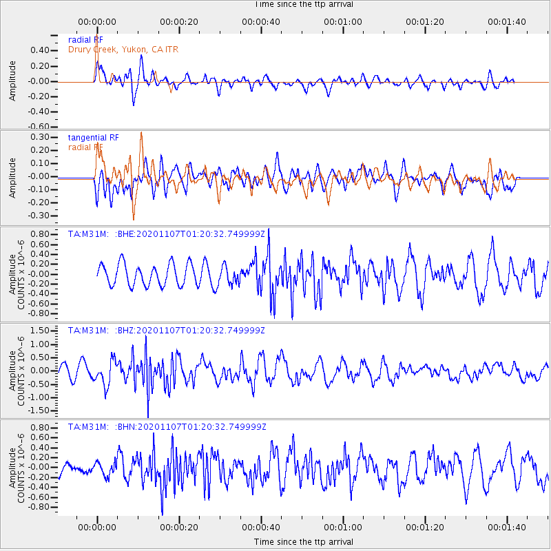
M31M Drury Creek, Yukon, CA - Earthquake Result Viewer
*The percent match for this event was below the threshold and hence no stack was calculated.
| Earthquake location: |
Volcano Islands, Japan Region |
| Earthquake latitude/longitude: |
25.7/143.6 |
| Earthquake time(UTC): |
2020/11/07 (312) 01:10:32 GMT |
| Earthquake Depth: |
18 km |
| Earthquake Magnitude: |
5.8 mww |
| Earthquake Catalog/Contributor: |
NEIC PDE/us |
|
| Network: |
TA USArray Transportable Network (new EarthScope stations) |
| Station: |
M31M Drury Creek, Yukon, CA |
| Lat/Lon: |
62.20 N/134.39 W |
| Elevation: |
639 m |
|
| Distance: |
63.9 deg |
| Az: |
31.125 deg |
| Baz: |
275.812 deg |
| Ray Param: |
$rayparam |
*The percent match for this event was below the threshold and hence was not used in the summary stack. |
|
| Radial Match: |
62.14691 % |
| Radial Bump: |
400 |
| Transverse Match: |
57.89339 % |
| Transverse Bump: |
400 |
| SOD ConfigId: |
23341671 |
| Insert Time: |
2020-11-21 02:28:45.205 +0000 |
| GWidth: |
2.5 |
| Max Bumps: |
400 |
| Tol: |
0.001 |
|
Signal To Noise
| Channel | StoN | STA | LTA |
| TA:M31M: :BHZ:20201107T01:20:32.749999Z | 2.1404214 | 4.6302776E-7 | 2.1632552E-7 |
| TA:M31M: :BHN:20201107T01:20:32.749999Z | 0.8158073 | 1.3299616E-7 | 1.63024E-7 |
| TA:M31M: :BHE:20201107T01:20:32.749999Z | 0.87182415 | 1.8572288E-7 | 2.1302792E-7 |
| Arrivals |
| Ps | |
| PpPs | |
| PsPs/PpSs | |


