You are here: Home > Network List > US - United States National Seismic Network Stations List
> Station EGMT Eagleton, Montana, USA > Earthquake Result Viewer
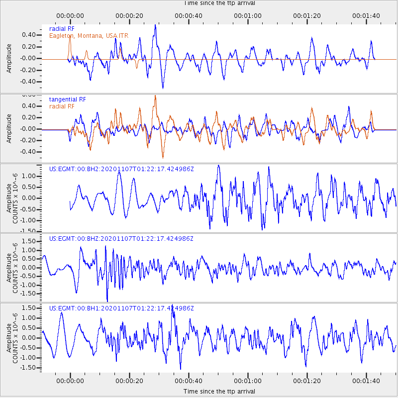
EGMT Eagleton, Montana, USA - Earthquake Result Viewer
*The percent match for this event was below the threshold and hence no stack was calculated.
| Earthquake location: |
Volcano Islands, Japan Region |
| Earthquake latitude/longitude: |
25.7/143.6 |
| Earthquake time(UTC): |
2020/11/07 (312) 01:10:32 GMT |
| Earthquake Depth: |
18 km |
| Earthquake Magnitude: |
5.8 mww |
| Earthquake Catalog/Contributor: |
NEIC PDE/us |
|
| Network: |
US United States National Seismic Network |
| Station: |
EGMT Eagleton, Montana, USA |
| Lat/Lon: |
48.02 N/109.75 W |
| Elevation: |
1055 m |
|
| Distance: |
81.6 deg |
| Az: |
40.561 deg |
| Baz: |
299.072 deg |
| Ray Param: |
$rayparam |
*The percent match for this event was below the threshold and hence was not used in the summary stack. |
|
| Radial Match: |
67.78029 % |
| Radial Bump: |
400 |
| Transverse Match: |
61.43642 % |
| Transverse Bump: |
400 |
| SOD ConfigId: |
23341671 |
| Insert Time: |
2020-11-21 02:30:21.874 +0000 |
| GWidth: |
2.5 |
| Max Bumps: |
400 |
| Tol: |
0.001 |
|
Signal To Noise
| Channel | StoN | STA | LTA |
| US:EGMT:00:BHZ:20201107T01:22:17.424986Z | 2.7147648 | 7.3683066E-7 | 2.71416E-7 |
| US:EGMT:00:BH1:20201107T01:22:17.424986Z | 1.2362832 | 5.691498E-7 | 4.603717E-7 |
| US:EGMT:00:BH2:20201107T01:22:17.424986Z | 0.62331456 | 2.9401937E-7 | 4.7170303E-7 |
| Arrivals |
| Ps | |
| PpPs | |
| PsPs/PpSs | |


