You are here: Home > Network List > AK - Alaska Regional Network Stations List
> Station G17K Kiwalik Mountain, AK, USA > Earthquake Result Viewer
G17K Kiwalik Mountain, AK, USA - Earthquake Result Viewer
| Earthquake location: |
Tonga Islands |
| Earthquake latitude/longitude: |
-15.3/-173.6 |
| Earthquake time(UTC): |
2020/11/07 (312) 09:27:04 GMT |
| Earthquake Depth: |
29 km |
| Earthquake Magnitude: |
6.1 Mww |
| Earthquake Catalog/Contributor: |
NEIC PDE/us |
|
| Network: |
AK Alaska Regional Network |
| Station: |
G17K Kiwalik Mountain, AK, USA |
| Lat/Lon: |
65.50 N/160.65 W |
| Elevation: |
338 m |
|
| Distance: |
81.1 deg |
| Az: |
5.41 deg |
| Baz: |
192.605 deg |
| Ray Param: |
0.047776535 |
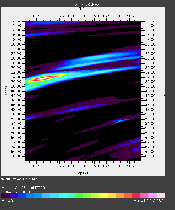
| Estimated Moho Depth: |
34.25 km |
| Estimated Crust Vp/Vs: |
1.69 |
| Assumed Crust Vp: |
6.276 km/s |
| Estimated Crust Vs: |
3.725 km/s |
| Estimated Crust Poisson's Ratio: |
0.23 |
|
| Radial Match: |
91.96946 % |
| Radial Bump: |
339 |
| Transverse Match: |
79.1913 % |
| Transverse Bump: |
399 |
| SOD ConfigId: |
23341671 |
| Insert Time: |
2020-11-21 10:32:18.323 +0000 |
| GWidth: |
2.5 |
| Max Bumps: |
400 |
| Tol: |
0.001 |
|

Signal To Noise
| Channel | StoN | STA | LTA |
| AK:G17K: :BHZ:20201107T09:38:46.099994Z | 10.257839 | 1.8019294E-6 | 1.7566364E-7 |
| AK:G17K: :BHN:20201107T09:38:46.099994Z | 3.236899 | 5.508459E-7 | 1.7017705E-7 |
| AK:G17K: :BHE:20201107T09:38:46.099994Z | 1.7075478 | 3.3163343E-7 | 1.942162E-7 |
| Arrivals |
| Ps | 3.8 SECOND |
| PpPs | 14 SECOND |
| PsPs/PpSs | 18 SECOND |


