You are here: Home > Network List > AK - Alaska Regional Network Stations List
> Station E21K Killik River, AK, USA > Earthquake Result Viewer
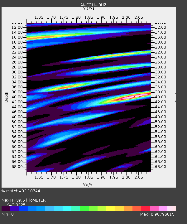
E21K Killik River, AK, USA - Earthquake Result Viewer
| Earthquake location: |
Tonga Islands |
| Earthquake latitude/longitude: |
-15.3/-173.6 |
| Earthquake time(UTC): |
2020/11/07 (312) 09:27:04 GMT |
| Earthquake Depth: |
29 km |
| Earthquake Magnitude: |
6.1 Mww |
| Earthquake Catalog/Contributor: |
NEIC PDE/us |
|
| Network: |
AK Alaska Regional Network |
| Station: |
E21K Killik River, AK, USA |
| Lat/Lon: |
68.44 N/153.97 W |
| Elevation: |
653 m |
|
| Distance: |
84.7 deg |
| Az: |
7.149 deg |
| Baz: |
198.964 deg |
| Ray Param: |
0.045281887 |
| Estimated Moho Depth: |
39.5 km |
| Estimated Crust Vp/Vs: |
2.03 |
| Assumed Crust Vp: |
6.221 km/s |
| Estimated Crust Vs: |
3.061 km/s |
| Estimated Crust Poisson's Ratio: |
0.34 |
|
| Radial Match: |
82.10744 % |
| Radial Bump: |
400 |
| Transverse Match: |
66.21161 % |
| Transverse Bump: |
400 |
| SOD ConfigId: |
23341671 |
| Insert Time: |
2020-11-21 10:32:40.863 +0000 |
| GWidth: |
2.5 |
| Max Bumps: |
400 |
| Tol: |
0.001 |
|

Signal To Noise
| Channel | StoN | STA | LTA |
| AK:E21K: :BHZ:20201107T09:39:04.440021Z | 6.6097364 | 1.3213794E-6 | 1.9991407E-7 |
| AK:E21K: :BHN:20201107T09:39:04.440021Z | 2.6311183 | 5.1157906E-7 | 1.9443408E-7 |
| AK:E21K: :BHE:20201107T09:39:04.440021Z | 1.7000775 | 3.40882E-7 | 2.0050967E-7 |
| Arrivals |
| Ps | 6.7 SECOND |
| PpPs | 19 SECOND |
| PsPs/PpSs | 26 SECOND |


