You are here: Home > Network List > AK - Alaska Regional Network Stations List
> Station L16K Owhat River, AK, USA > Earthquake Result Viewer
L16K Owhat River, AK, USA - Earthquake Result Viewer
| Earthquake location: |
Tonga Islands |
| Earthquake latitude/longitude: |
-15.3/-173.6 |
| Earthquake time(UTC): |
2020/11/07 (312) 09:27:04 GMT |
| Earthquake Depth: |
29 km |
| Earthquake Magnitude: |
6.1 Mww |
| Earthquake Catalog/Contributor: |
NEIC PDE/us |
|
| Network: |
AK Alaska Regional Network |
| Station: |
L16K Owhat River, AK, USA |
| Lat/Lon: |
61.71 N/159.47 W |
| Elevation: |
227 m |
|
| Distance: |
77.5 deg |
| Az: |
6.819 deg |
| Baz: |
193.919 deg |
| Ray Param: |
0.050225314 |
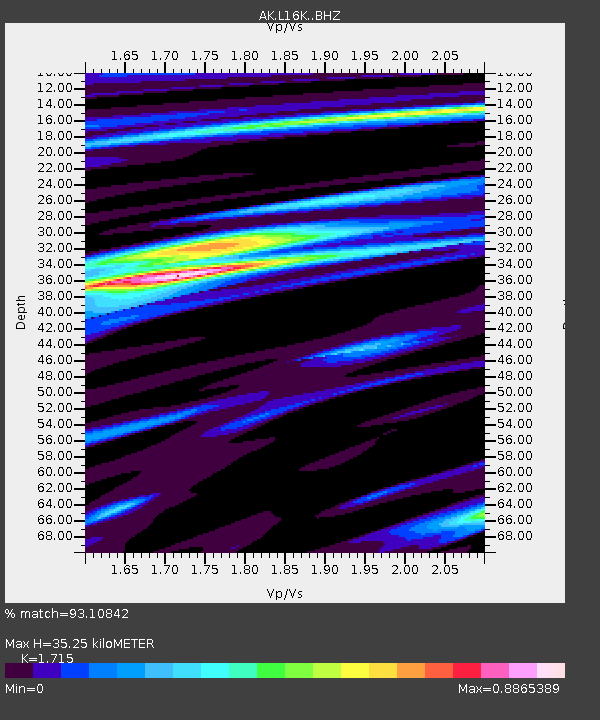
| Estimated Moho Depth: |
35.25 km |
| Estimated Crust Vp/Vs: |
1.72 |
| Assumed Crust Vp: |
6.276 km/s |
| Estimated Crust Vs: |
3.659 km/s |
| Estimated Crust Poisson's Ratio: |
0.24 |
|
| Radial Match: |
93.10842 % |
| Radial Bump: |
287 |
| Transverse Match: |
83.51389 % |
| Transverse Bump: |
340 |
| SOD ConfigId: |
23341671 |
| Insert Time: |
2020-11-21 10:32:43.862 +0000 |
| GWidth: |
2.5 |
| Max Bumps: |
400 |
| Tol: |
0.001 |
|

Signal To Noise
| Channel | StoN | STA | LTA |
| AK:L16K: :BHZ:20201107T09:38:26.620013Z | 12.644348 | 2.9116457E-6 | 2.3027249E-7 |
| AK:L16K: :BHN:20201107T09:38:26.620013Z | 4.260463 | 1.3396188E-6 | 3.1443034E-7 |
| AK:L16K: :BHE:20201107T09:38:26.620013Z | 2.3392487 | 5.778776E-7 | 2.4703556E-7 |
| Arrivals |
| Ps | 4.1 SECOND |
| PpPs | 15 SECOND |
| PsPs/PpSs | 19 SECOND |


