You are here: Home > Network List > IW - Intermountain West Stations List
> Station MOOW Moose Ponds, Wyoming, USA > Earthquake Result Viewer
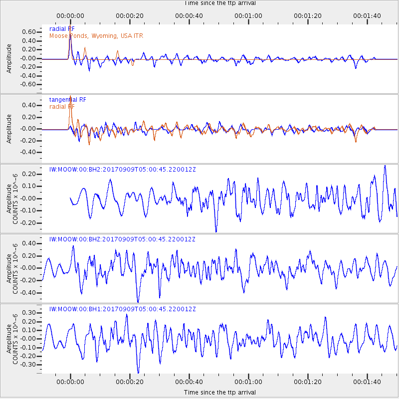
MOOW Moose Ponds, Wyoming, USA - Earthquake Result Viewer
*The percent match for this event was below the threshold and hence no stack was calculated.
| Earthquake location: |
Near Coast Of Chiapas, Mexico |
| Earthquake latitude/longitude: |
15.1/-93.9 |
| Earthquake time(UTC): |
2017/09/09 (252) 04:54:52 GMT |
| Earthquake Depth: |
29 km |
| Earthquake Magnitude: |
5.5 Mww |
| Earthquake Catalog/Contributor: |
NEIC PDE/us |
|
| Network: |
IW Intermountain West |
| Station: |
MOOW Moose Ponds, Wyoming, USA |
| Lat/Lon: |
43.75 N/110.74 W |
| Elevation: |
2128 m |
|
| Distance: |
32.0 deg |
| Az: |
336.684 deg |
| Baz: |
148.158 deg |
| Ray Param: |
$rayparam |
*The percent match for this event was below the threshold and hence was not used in the summary stack. |
|
| Radial Match: |
67.79148 % |
| Radial Bump: |
400 |
| Transverse Match: |
56.698956 % |
| Transverse Bump: |
400 |
| SOD ConfigId: |
2307692 |
| Insert Time: |
2017-09-28 23:29:08.569 +0000 |
| GWidth: |
2.5 |
| Max Bumps: |
400 |
| Tol: |
0.001 |
|
Signal To Noise
| Channel | StoN | STA | LTA |
| IW:MOOW:00:BHZ:20170909T05:00:45.220012Z | 2.0969536 | 2.0471553E-7 | 9.7625204E-8 |
| IW:MOOW:00:BH1:20170909T05:00:45.220012Z | 2.1554067 | 1.3558294E-7 | 6.2903645E-8 |
| IW:MOOW:00:BH2:20170909T05:00:45.220012Z | 0.677795 | 4.5146805E-8 | 6.6608344E-8 |
| Arrivals |
| Ps | |
| PpPs | |
| PsPs/PpSs | |


