You are here: Home > Network List > IW - Intermountain West Stations List
> Station PLID Pearl Lake, Idaho, USA > Earthquake Result Viewer
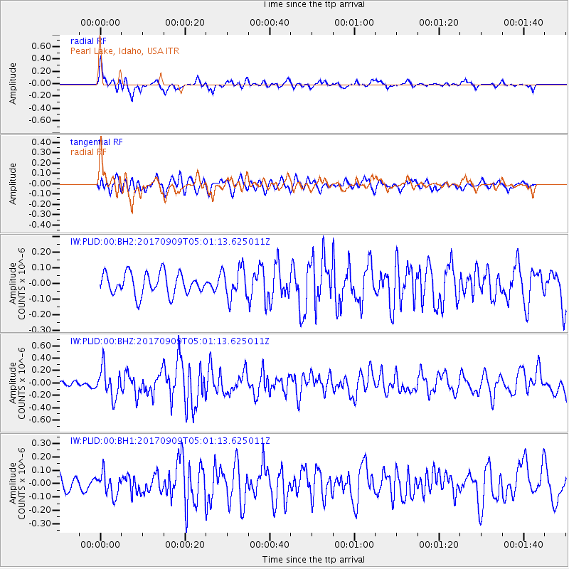
PLID Pearl Lake, Idaho, USA - Earthquake Result Viewer
*The percent match for this event was below the threshold and hence no stack was calculated.
| Earthquake location: |
Near Coast Of Chiapas, Mexico |
| Earthquake latitude/longitude: |
15.1/-93.9 |
| Earthquake time(UTC): |
2017/09/09 (252) 04:54:52 GMT |
| Earthquake Depth: |
29 km |
| Earthquake Magnitude: |
5.5 Mww |
| Earthquake Catalog/Contributor: |
NEIC PDE/us |
|
| Network: |
IW Intermountain West |
| Station: |
PLID Pearl Lake, Idaho, USA |
| Lat/Lon: |
45.09 N/116.00 W |
| Elevation: |
2164 m |
|
| Distance: |
35.2 deg |
| Az: |
332.538 deg |
| Baz: |
141.036 deg |
| Ray Param: |
$rayparam |
*The percent match for this event was below the threshold and hence was not used in the summary stack. |
|
| Radial Match: |
60.265537 % |
| Radial Bump: |
400 |
| Transverse Match: |
54.00292 % |
| Transverse Bump: |
400 |
| SOD ConfigId: |
2307692 |
| Insert Time: |
2017-09-28 23:29:11.113 +0000 |
| GWidth: |
2.5 |
| Max Bumps: |
400 |
| Tol: |
0.001 |
|
Signal To Noise
| Channel | StoN | STA | LTA |
| IW:PLID:00:BHZ:20170909T05:01:13.625011Z | 2.9511116 | 2.387842E-7 | 8.09133E-8 |
| IW:PLID:00:BH1:20170909T05:01:13.625011Z | 1.3336632 | 8.39986E-8 | 6.298337E-8 |
| IW:PLID:00:BH2:20170909T05:01:13.625011Z | 1.4071223 | 9.604298E-8 | 6.825489E-8 |
| Arrivals |
| Ps | |
| PpPs | |
| PsPs/PpSs | |


