You are here: Home > Network List > AV - Alaska Volcano Observatory Stations List
> Station ILS Iliamna South, Iliamna Volcano, Alaska > Earthquake Result Viewer
ILS Iliamna South, Iliamna Volcano, Alaska - Earthquake Result Viewer
| Earthquake location: |
Tonga Islands |
| Earthquake latitude/longitude: |
-15.3/-173.6 |
| Earthquake time(UTC): |
2020/11/07 (312) 09:27:04 GMT |
| Earthquake Depth: |
29 km |
| Earthquake Magnitude: |
6.1 Mww |
| Earthquake Catalog/Contributor: |
NEIC PDE/us |
|
| Network: |
AV Alaska Volcano Observatory |
| Station: |
ILS Iliamna South, Iliamna Volcano, Alaska |
| Lat/Lon: |
59.96 N/153.07 W |
| Elevation: |
1125 m |
|
| Distance: |
76.8 deg |
| Az: |
10.424 deg |
| Baz: |
200.306 deg |
| Ray Param: |
0.050728187 |
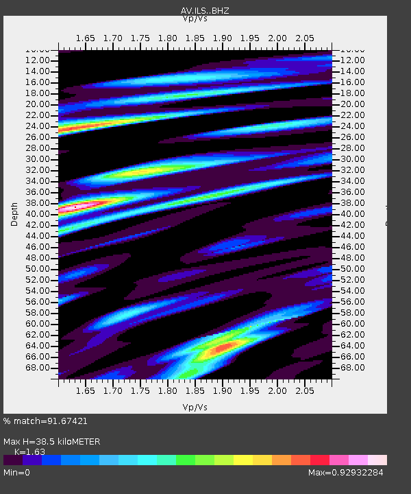
| Estimated Moho Depth: |
38.5 km |
| Estimated Crust Vp/Vs: |
1.63 |
| Assumed Crust Vp: |
5.989 km/s |
| Estimated Crust Vs: |
3.674 km/s |
| Estimated Crust Poisson's Ratio: |
0.20 |
|
| Radial Match: |
91.67421 % |
| Radial Bump: |
400 |
| Transverse Match: |
72.79302 % |
| Transverse Bump: |
400 |
| SOD ConfigId: |
23341671 |
| Insert Time: |
2020-11-21 10:34:20.650 +0000 |
| GWidth: |
2.5 |
| Max Bumps: |
400 |
| Tol: |
0.001 |
|

Signal To Noise
| Channel | StoN | STA | LTA |
| AV:ILS: :BHZ:20201107T09:38:22.399005Z | 14.909644 | 1.6690956E-6 | 1.1194738E-7 |
| AV:ILS: :BHN:20201107T09:38:22.399005Z | 9.376033 | 9.0385043E-7 | 9.640009E-8 |
| AV:ILS: :BHE:20201107T09:38:22.399005Z | 2.5816252 | 8.3956854E-7 | 3.252093E-7 |
| Arrivals |
| Ps | 4.2 SECOND |
| PpPs | 16 SECOND |
| PsPs/PpSs | 21 SECOND |


