You are here: Home > Network List > AV - Alaska Volcano Observatory Stations List
> Station PLBL Mt. Peulik Volcano, Alaska > Earthquake Result Viewer
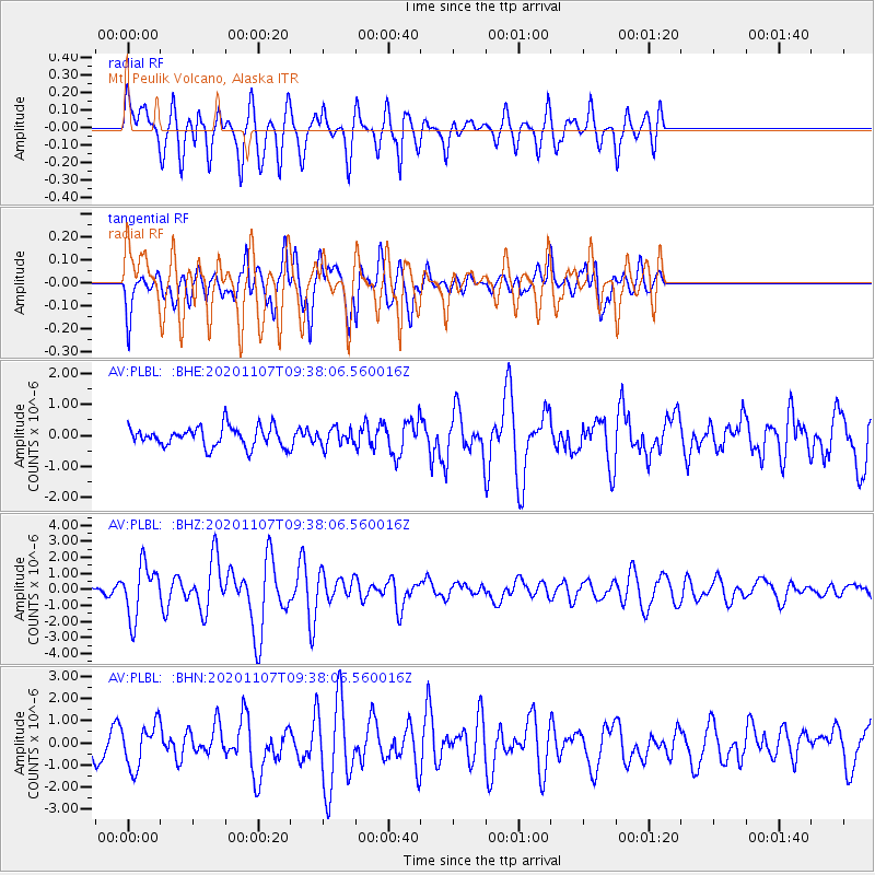
PLBL Mt. Peulik Volcano, Alaska - Earthquake Result Viewer
*The percent match for this event was below the threshold and hence no stack was calculated.
| Earthquake location: |
Tonga Islands |
| Earthquake latitude/longitude: |
-15.3/-173.6 |
| Earthquake time(UTC): |
2020/11/07 (312) 09:27:04 GMT |
| Earthquake Depth: |
29 km |
| Earthquake Magnitude: |
6.1 Mww |
| Earthquake Catalog/Contributor: |
NEIC PDE/us |
|
| Network: |
AV Alaska Volcano Observatory |
| Station: |
PLBL Mt. Peulik Volcano, Alaska |
| Lat/Lon: |
57.70 N/156.82 W |
| Elevation: |
461 m |
|
| Distance: |
74.0 deg |
| Az: |
9.257 deg |
| Baz: |
196.808 deg |
| Ray Param: |
$rayparam |
*The percent match for this event was below the threshold and hence was not used in the summary stack. |
|
| Radial Match: |
62.675747 % |
| Radial Bump: |
400 |
| Transverse Match: |
55.44642 % |
| Transverse Bump: |
400 |
| SOD ConfigId: |
23341671 |
| Insert Time: |
2020-11-21 10:34:58.214 +0000 |
| GWidth: |
2.5 |
| Max Bumps: |
400 |
| Tol: |
0.001 |
|
Signal To Noise
| Channel | StoN | STA | LTA |
| AV:PLBL: :BHZ:20201107T09:38:06.560016Z | 6.312103 | 1.6506707E-6 | 2.6150886E-7 |
| AV:PLBL: :BHN:20201107T09:38:06.560016Z | 1.671182 | 9.769043E-7 | 5.8455885E-7 |
| AV:PLBL: :BHE:20201107T09:38:06.560016Z | 0.84403914 | 2.7235737E-7 | 3.2268335E-7 |
| Arrivals |
| Ps | |
| PpPs | |
| PsPs/PpSs | |


