You are here: Home > Network List > AV - Alaska Volcano Observatory Stations List
> Station Q17K Contact Creek, Katmai, AK, USA > Earthquake Result Viewer
Q17K Contact Creek, Katmai, AK, USA - Earthquake Result Viewer
| Earthquake location: |
Tonga Islands |
| Earthquake latitude/longitude: |
-15.3/-173.6 |
| Earthquake time(UTC): |
2020/11/07 (312) 09:27:04 GMT |
| Earthquake Depth: |
29 km |
| Earthquake Magnitude: |
6.1 Mww |
| Earthquake Catalog/Contributor: |
NEIC PDE/us |
|
| Network: |
AV Alaska Volcano Observatory |
| Station: |
Q17K Contact Creek, Katmai, AK, USA |
| Lat/Lon: |
58.26 N/155.89 W |
| Elevation: |
1165 m |
|
| Distance: |
74.7 deg |
| Az: |
9.577 deg |
| Baz: |
197.685 deg |
| Ray Param: |
0.052120786 |
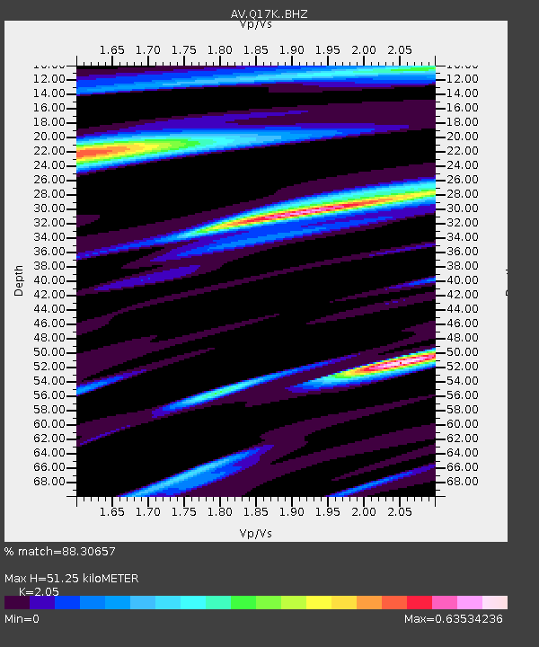
| Estimated Moho Depth: |
51.25 km |
| Estimated Crust Vp/Vs: |
2.05 |
| Assumed Crust Vp: |
6.438 km/s |
| Estimated Crust Vs: |
3.141 km/s |
| Estimated Crust Poisson's Ratio: |
0.34 |
|
| Radial Match: |
88.30657 % |
| Radial Bump: |
400 |
| Transverse Match: |
68.10582 % |
| Transverse Bump: |
400 |
| SOD ConfigId: |
23341671 |
| Insert Time: |
2020-11-21 10:35:45.067 +0000 |
| GWidth: |
2.5 |
| Max Bumps: |
400 |
| Tol: |
0.001 |
|

Signal To Noise
| Channel | StoN | STA | LTA |
| AV:Q17K: :BHZ:20201107T09:38:10.550006Z | 7.4224224 | 2.3652985E-6 | 3.1866935E-7 |
| AV:Q17K: :BHN:20201107T09:38:10.550006Z | 5.977878 | 9.547758E-7 | 1.5971817E-7 |
| AV:Q17K: :BHE:20201107T09:38:10.550006Z | 0.9610578 | 4.262683E-7 | 4.4354076E-7 |
| Arrivals |
| Ps | 8.6 SECOND |
| PpPs | 24 SECOND |
| PsPs/PpSs | 32 SECOND |


