You are here: Home > Network List > CC - Cascade Chain Volcano Monitoring Stations List
> Station SIFT Swift Creek > Earthquake Result Viewer
SIFT Swift Creek - Earthquake Result Viewer
| Earthquake location: |
Tonga Islands |
| Earthquake latitude/longitude: |
-15.3/-173.6 |
| Earthquake time(UTC): |
2020/11/07 (312) 09:27:04 GMT |
| Earthquake Depth: |
29 km |
| Earthquake Magnitude: |
6.1 Mww |
| Earthquake Catalog/Contributor: |
NEIC PDE/us |
|
| Network: |
CC Cascade Chain Volcano Monitoring |
| Station: |
SIFT Swift Creek |
| Lat/Lon: |
46.87 N/121.95 W |
| Elevation: |
732 m |
|
| Distance: |
77.2 deg |
| Az: |
33.462 deg |
| Baz: |
230.858 deg |
| Ray Param: |
0.05041715 |
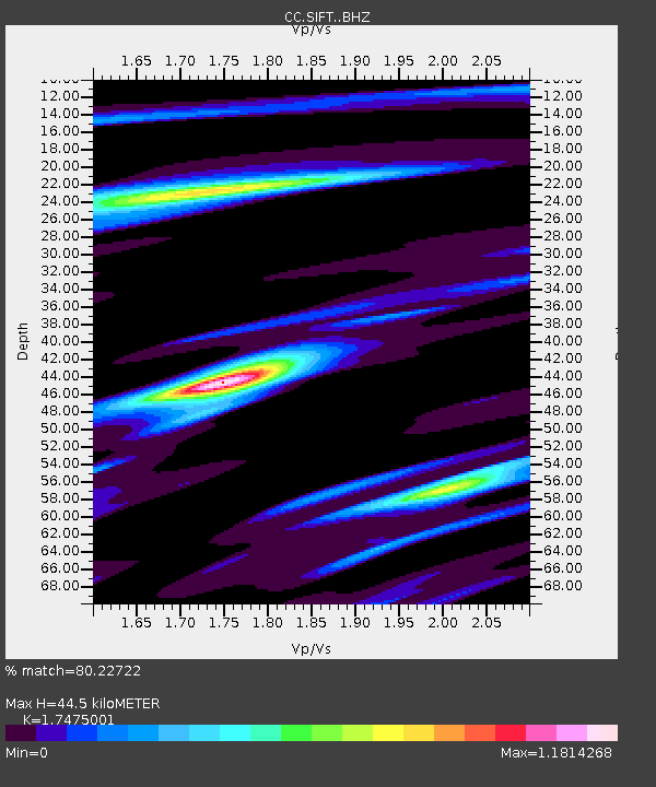
| Estimated Moho Depth: |
44.5 km |
| Estimated Crust Vp/Vs: |
1.75 |
| Assumed Crust Vp: |
6.597 km/s |
| Estimated Crust Vs: |
3.775 km/s |
| Estimated Crust Poisson's Ratio: |
0.26 |
|
| Radial Match: |
80.22722 % |
| Radial Bump: |
400 |
| Transverse Match: |
57.10998 % |
| Transverse Bump: |
400 |
| SOD ConfigId: |
23341671 |
| Insert Time: |
2020-11-21 10:38:29.689 +0000 |
| GWidth: |
2.5 |
| Max Bumps: |
400 |
| Tol: |
0.001 |
|

Signal To Noise
| Channel | StoN | STA | LTA |
| CC:SIFT: :BHZ:20201107T09:38:24.979999Z | 4.3725767 | 1.6124368E-6 | 3.6876122E-7 |
| CC:SIFT: :BHN:20201107T09:38:24.979999Z | 0.7689499 | 4.5981733E-7 | 5.979809E-7 |
| CC:SIFT: :BHE:20201107T09:38:24.979999Z | 1.519705 | 8.5241913E-7 | 5.609109E-7 |
| Arrivals |
| Ps | 5.2 SECOND |
| PpPs | 18 SECOND |
| PsPs/PpSs | 23 SECOND |


