You are here: Home > Network List > CI - Caltech Regional Seismic Network Stations List
> Station SLA SLA, Trona, CA, USA > Earthquake Result Viewer
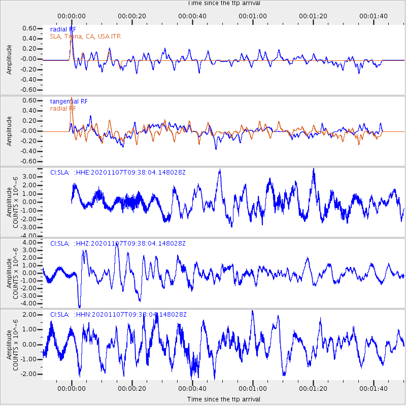
SLA SLA, Trona, CA, USA - Earthquake Result Viewer
*The percent match for this event was below the threshold and hence no stack was calculated.
| Earthquake location: |
Tonga Islands |
| Earthquake latitude/longitude: |
-15.3/-173.6 |
| Earthquake time(UTC): |
2020/11/07 (312) 09:27:04 GMT |
| Earthquake Depth: |
29 km |
| Earthquake Magnitude: |
6.1 Mww |
| Earthquake Catalog/Contributor: |
NEIC PDE/us |
|
| Network: |
CI Caltech Regional Seismic Network |
| Station: |
SLA SLA, Trona, CA, USA |
| Lat/Lon: |
35.89 N/117.28 W |
| Elevation: |
1174 m |
|
| Distance: |
73.6 deg |
| Az: |
44.749 deg |
| Baz: |
236.799 deg |
| Ray Param: |
$rayparam |
*The percent match for this event was below the threshold and hence was not used in the summary stack. |
|
| Radial Match: |
73.86486 % |
| Radial Bump: |
400 |
| Transverse Match: |
71.91419 % |
| Transverse Bump: |
400 |
| SOD ConfigId: |
23341671 |
| Insert Time: |
2020-11-21 10:40:11.617 +0000 |
| GWidth: |
2.5 |
| Max Bumps: |
400 |
| Tol: |
0.001 |
|
Signal To Noise
| Channel | StoN | STA | LTA |
| CI:SLA: :HHZ:20201107T09:38:04.148028Z | 3.973172 | 2.1094404E-6 | 5.30921E-7 |
| CI:SLA: :HHN:20201107T09:38:04.148028Z | 1.828544 | 9.5298583E-7 | 5.2117196E-7 |
| CI:SLA: :HHE:20201107T09:38:04.148028Z | 2.1917026 | 1.5866516E-6 | 7.239356E-7 |
| Arrivals |
| Ps | |
| PpPs | |
| PsPs/PpSs | |


