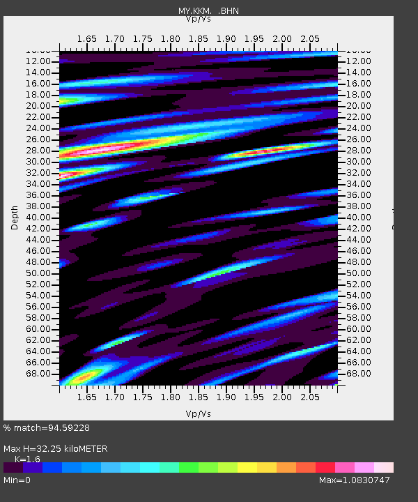
KKM Kota Kinabalu - Earthquake Result Viewer

Earthquake location: Pakistan
Earthquake latitude/longitude: 34.7/73.2
Earthquake time(UTC): 2005/10/08 (281) 21:13:31 GMT
Earthquake Depth: 10 km
Earthquake Magnitude: 5.9 MB, 5.1 MS, 5.7 MW, 5.6 MW
Earthquake Catalog/Contributor: WHDF/NEIC
Network: MY Malaysian National Seismic Network
Station: KKM Kota Kinabalu
Lat/Lon: 6.04 N/116.21 E
Elevation: 830 m
Distance: 48.8 deg
Az: 115.669 deg
Baz: 311.719 deg
Ray Param: 0.06908793
Estimated Moho Depth: 32.25 km
Estimated Crust Vp/Vs: 1.60
Assumed Crust Vp: 6.048 km/s
Estimated Crust Vs: 3.78 km/s
Estimated Crust Poisson's Ratio: 0.18
Radial Match: 94.59228 %
Radial Bump: 400
Transverse Match: 80.49111 %
Transverse Bump: 400
SOD ConfigId: 2500
Insert Time: 2010-03-09 03:23:08.993 +0000
GWidth: 2.5
Max Bumps: 400
Tol: 0.001

Signal To Noise

ChannelStoNSTALTA
MY:KKM: :BHN:20051008T21:21:46.469009Z13.7935581.6045814E-61.1632832E-7
MY:KKM: :BHE:20051008T21:21:46.469009Z5.9411167.919219E-71.3329515E-7
MY:KKM: :BHZ:20051008T21:21:46.469009Z47.987213.6877304E-67.6848195E-8
Arrivals
Ps3.4 SECOND
PpPs13 SECOND
PsPs/PpSs16 SECOND