You are here: Home > Network List > TA - USArray Transportable Network (new EarthScope stations) Stations List
> Station F31M Tsiigehtchic, NWT, CAN > Earthquake Result Viewer
F31M Tsiigehtchic, NWT, CAN - Earthquake Result Viewer
| Earthquake location: |
Tonga Islands |
| Earthquake latitude/longitude: |
-15.3/-173.6 |
| Earthquake time(UTC): |
2020/11/07 (312) 09:27:04 GMT |
| Earthquake Depth: |
29 km |
| Earthquake Magnitude: |
6.1 Mww |
| Earthquake Catalog/Contributor: |
NEIC PDE/us |
|
| Network: |
TA USArray Transportable Network (new EarthScope stations) |
| Station: |
F31M Tsiigehtchic, NWT, CAN |
| Lat/Lon: |
67.44 N/133.74 W |
| Elevation: |
56 m |
|
| Distance: |
87.4 deg |
| Az: |
14.319 deg |
| Baz: |
218.217 deg |
| Ray Param: |
0.043284014 |
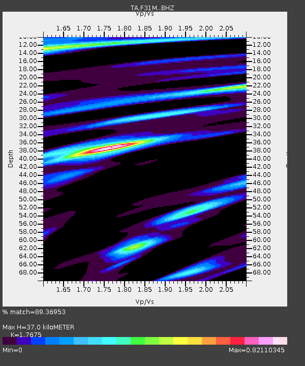
| Estimated Moho Depth: |
37.0 km |
| Estimated Crust Vp/Vs: |
1.77 |
| Assumed Crust Vp: |
6.171 km/s |
| Estimated Crust Vs: |
3.492 km/s |
| Estimated Crust Poisson's Ratio: |
0.26 |
|
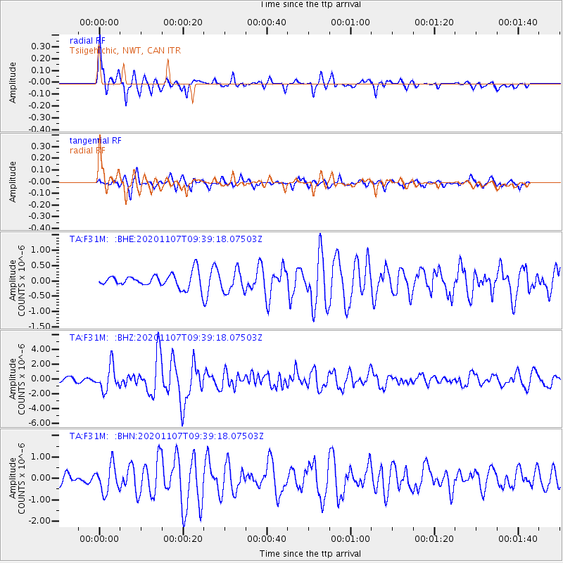
| Radial Match: |
89.36953 % |
| Radial Bump: |
392 |
| Transverse Match: |
72.52835 % |
| Transverse Bump: |
390 |
| SOD ConfigId: |
23341671 |
| Insert Time: |
2020-11-21 10:51:51.469 +0000 |
| GWidth: |
2.5 |
| Max Bumps: |
400 |
| Tol: |
0.001 |
|
Signal To Noise
| Channel | StoN | STA | LTA |
| TA:F31M: :BHZ:20201107T09:39:18.07503Z | 6.185369 | 1.68713E-6 | 2.727614E-7 |
| TA:F31M: :BHN:20201107T09:39:18.07503Z | 3.9278693 | 6.400785E-7 | 1.6295819E-7 |
| TA:F31M: :BHE:20201107T09:39:18.07503Z | 1.5628605 | 3.5402175E-7 | 2.2652166E-7 |
| Arrivals |
| Ps | 4.7 SECOND |
| PpPs | 16 SECOND |
| PsPs/PpSs | 21 SECOND |


