You are here: Home > Network List > TA - USArray Transportable Network (new EarthScope stations) Stations List
> Station G18K Tagagawik, AK, USA > Earthquake Result Viewer
G18K Tagagawik, AK, USA - Earthquake Result Viewer
| Earthquake location: |
Tonga Islands |
| Earthquake latitude/longitude: |
-15.3/-173.6 |
| Earthquake time(UTC): |
2020/11/07 (312) 09:27:04 GMT |
| Earthquake Depth: |
29 km |
| Earthquake Magnitude: |
6.1 Mww |
| Earthquake Catalog/Contributor: |
NEIC PDE/us |
|
| Network: |
TA USArray Transportable Network (new EarthScope stations) |
| Station: |
G18K Tagagawik, AK, USA |
| Lat/Lon: |
65.89 N/158.65 W |
| Elevation: |
484 m |
|
| Distance: |
81.7 deg |
| Az: |
6.129 deg |
| Baz: |
194.531 deg |
| Ray Param: |
0.047369525 |
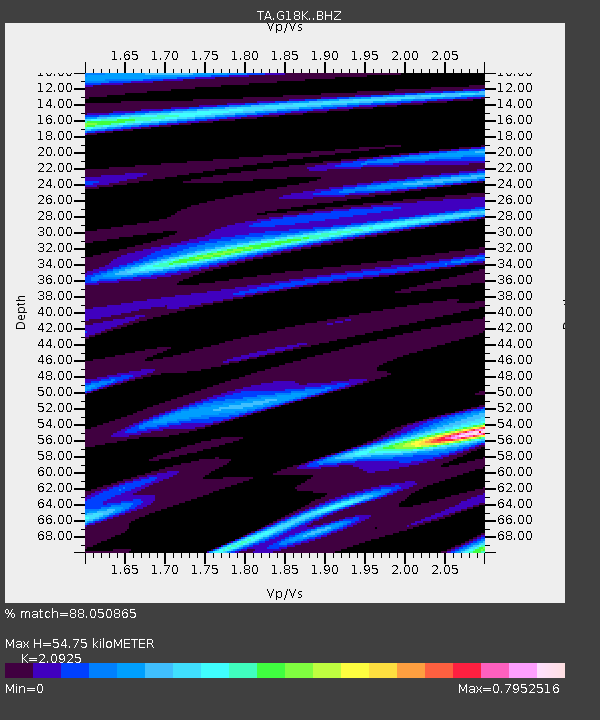
| Estimated Moho Depth: |
54.75 km |
| Estimated Crust Vp/Vs: |
2.09 |
| Assumed Crust Vp: |
6.1 km/s |
| Estimated Crust Vs: |
2.915 km/s |
| Estimated Crust Poisson's Ratio: |
0.35 |
|
| Radial Match: |
88.050865 % |
| Radial Bump: |
396 |
| Transverse Match: |
82.78806 % |
| Transverse Bump: |
384 |
| SOD ConfigId: |
23341671 |
| Insert Time: |
2020-11-21 10:51:54.564 +0000 |
| GWidth: |
2.5 |
| Max Bumps: |
400 |
| Tol: |
0.001 |
|

Signal To Noise
| Channel | StoN | STA | LTA |
| TA:G18K: :BHZ:20201107T09:38:49.149981Z | 6.215359 | 1.3853389E-6 | 2.2288961E-7 |
| TA:G18K: :BHN:20201107T09:38:49.149981Z | 3.4343672 | 5.798562E-7 | 1.6883932E-7 |
| TA:G18K: :BHE:20201107T09:38:49.149981Z | 1.5838058 | 2.3255504E-7 | 1.4683305E-7 |
| Arrivals |
| Ps | 10 SECOND |
| PpPs | 27 SECOND |
| PsPs/PpSs | 37 SECOND |


