You are here: Home > Network List > TA - USArray Transportable Network (new EarthScope stations) Stations List
> Station L29M Grand Valley Creek, YT, CAN > Earthquake Result Viewer
L29M Grand Valley Creek, YT, CAN - Earthquake Result Viewer
| Earthquake location: |
Tonga Islands |
| Earthquake latitude/longitude: |
-15.3/-173.6 |
| Earthquake time(UTC): |
2020/11/07 (312) 09:27:04 GMT |
| Earthquake Depth: |
29 km |
| Earthquake Magnitude: |
6.1 Mww |
| Earthquake Catalog/Contributor: |
NEIC PDE/us |
|
| Network: |
TA USArray Transportable Network (new EarthScope stations) |
| Station: |
L29M Grand Valley Creek, YT, CAN |
| Lat/Lon: |
63.11 N/138.13 W |
| Elevation: |
918 m |
|
| Distance: |
82.9 deg |
| Az: |
15.407 deg |
| Baz: |
214.325 deg |
| Ray Param: |
0.04656778 |
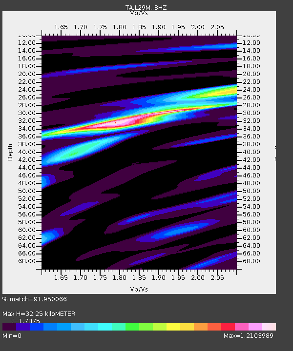
| Estimated Moho Depth: |
32.25 km |
| Estimated Crust Vp/Vs: |
1.79 |
| Assumed Crust Vp: |
6.566 km/s |
| Estimated Crust Vs: |
3.673 km/s |
| Estimated Crust Poisson's Ratio: |
0.27 |
|
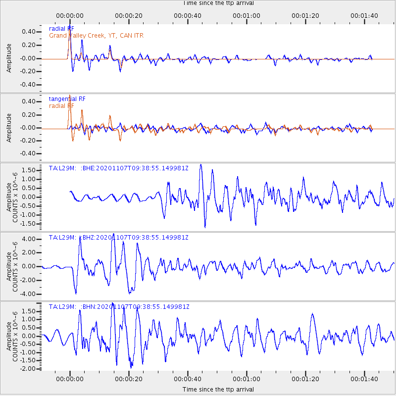
| Radial Match: |
91.950066 % |
| Radial Bump: |
343 |
| Transverse Match: |
74.38622 % |
| Transverse Bump: |
400 |
| SOD ConfigId: |
23341671 |
| Insert Time: |
2020-11-21 10:52:32.359 +0000 |
| GWidth: |
2.5 |
| Max Bumps: |
400 |
| Tol: |
0.001 |
|
Signal To Noise
| Channel | StoN | STA | LTA |
| TA:L29M: :BHZ:20201107T09:38:55.149981Z | 13.538303 | 2.0548312E-6 | 1.5177908E-7 |
| TA:L29M: :BHN:20201107T09:38:55.149981Z | 4.5519004 | 6.6985956E-7 | 1.4716042E-7 |
| TA:L29M: :BHE:20201107T09:38:55.149981Z | 3.6527214 | 5.327333E-7 | 1.4584559E-7 |
| Arrivals |
| Ps | 4.0 SECOND |
| PpPs | 13 SECOND |
| PsPs/PpSs | 17 SECOND |


