You are here: Home > Network List > TA - USArray Transportable Network (new EarthScope stations) Stations List
> Station P33M Teslin, Yukon, CA > Earthquake Result Viewer
P33M Teslin, Yukon, CA - Earthquake Result Viewer
| Earthquake location: |
Tonga Islands |
| Earthquake latitude/longitude: |
-15.3/-173.6 |
| Earthquake time(UTC): |
2020/11/07 (312) 09:27:04 GMT |
| Earthquake Depth: |
29 km |
| Earthquake Magnitude: |
6.1 Mww |
| Earthquake Catalog/Contributor: |
NEIC PDE/us |
|
| Network: |
TA USArray Transportable Network (new EarthScope stations) |
| Station: |
P33M Teslin, Yukon, CA |
| Lat/Lon: |
60.21 N/132.82 W |
| Elevation: |
1066 m |
|
| Distance: |
82.1 deg |
| Az: |
19.211 deg |
| Baz: |
219.495 deg |
| Ray Param: |
0.047120683 |
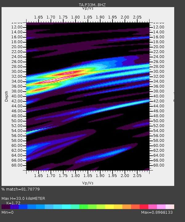
| Estimated Moho Depth: |
33.0 km |
| Estimated Crust Vp/Vs: |
1.72 |
| Assumed Crust Vp: |
6.419 km/s |
| Estimated Crust Vs: |
3.732 km/s |
| Estimated Crust Poisson's Ratio: |
0.24 |
|
| Radial Match: |
81.78779 % |
| Radial Bump: |
276 |
| Transverse Match: |
55.99409 % |
| Transverse Bump: |
339 |
| SOD ConfigId: |
23341671 |
| Insert Time: |
2020-11-21 10:53:06.750 +0000 |
| GWidth: |
2.5 |
| Max Bumps: |
400 |
| Tol: |
0.001 |
|

Signal To Noise
| Channel | StoN | STA | LTA |
| TA:P33M: :BHZ:20201107T09:38:50.974994Z | 6.0815835 | 1.1579948E-6 | 1.9041009E-7 |
| TA:P33M: :BHN:20201107T09:38:50.974994Z | 1.9204401 | 4.5130625E-7 | 2.3500147E-7 |
| TA:P33M: :BHE:20201107T09:38:50.974994Z | 1.3700356 | 3.5065676E-7 | 2.5594719E-7 |
| Arrivals |
| Ps | 3.8 SECOND |
| PpPs | 14 SECOND |
| PsPs/PpSs | 17 SECOND |


