You are here: Home > Network List > TA - USArray Transportable Network (new EarthScope stations) Stations List
> Station R31K City Hall, Gustavus, AK, USA > Earthquake Result Viewer
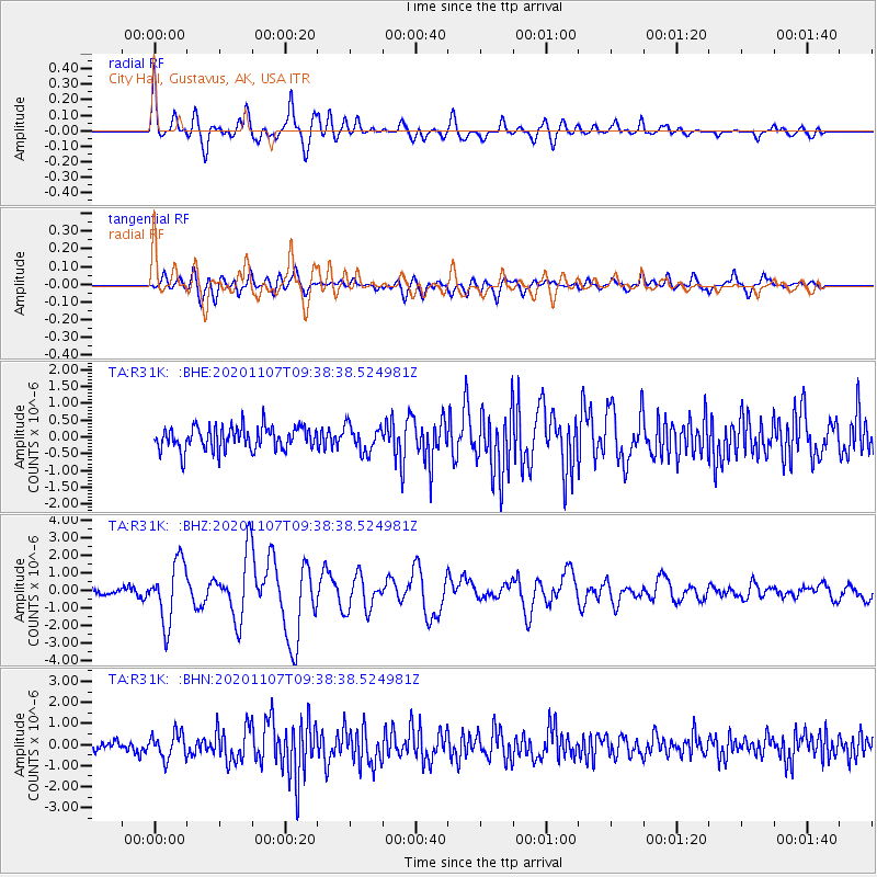
R31K City Hall, Gustavus, AK, USA - Earthquake Result Viewer
*The percent match for this event was below the threshold and hence no stack was calculated.
| Earthquake location: |
Tonga Islands |
| Earthquake latitude/longitude: |
-15.3/-173.6 |
| Earthquake time(UTC): |
2020/11/07 (312) 09:27:04 GMT |
| Earthquake Depth: |
29 km |
| Earthquake Magnitude: |
6.1 Mww |
| Earthquake Catalog/Contributor: |
NEIC PDE/us |
|
| Network: |
TA USArray Transportable Network (new EarthScope stations) |
| Station: |
R31K City Hall, Gustavus, AK, USA |
| Lat/Lon: |
58.41 N/135.74 W |
| Elevation: |
15 m |
|
| Distance: |
79.7 deg |
| Az: |
19.149 deg |
| Baz: |
216.976 deg |
| Ray Param: |
$rayparam |
*The percent match for this event was below the threshold and hence was not used in the summary stack. |
|
| Radial Match: |
79.68752 % |
| Radial Bump: |
400 |
| Transverse Match: |
50.74664 % |
| Transverse Bump: |
400 |
| SOD ConfigId: |
23341671 |
| Insert Time: |
2020-11-21 10:53:09.705 +0000 |
| GWidth: |
2.5 |
| Max Bumps: |
400 |
| Tol: |
0.001 |
|
Signal To Noise
| Channel | StoN | STA | LTA |
| TA:R31K: :BHZ:20201107T09:38:38.524981Z | 7.64429 | 1.7125669E-6 | 2.2403218E-7 |
| TA:R31K: :BHN:20201107T09:38:38.524981Z | 1.8874565 | 5.8781643E-7 | 3.114331E-7 |
| TA:R31K: :BHE:20201107T09:38:38.524981Z | 1.1593816 | 3.995324E-7 | 3.4460817E-7 |
| Arrivals |
| Ps | |
| PpPs | |
| PsPs/PpSs | |


