You are here: Home > Network List > MY - Malaysian National Seismic Network Stations List
> Station KKM Kota Kinabalu > Earthquake Result Viewer
KKM Kota Kinabalu - Earthquake Result Viewer
| Earthquake location: |
South Of Fiji Islands |
| Earthquake latitude/longitude: |
-26.1/-178.4 |
| Earthquake time(UTC): |
2009/08/18 (230) 21:20:47 GMT |
| Earthquake Depth: |
270 km |
| Earthquake Magnitude: |
5.5 MB, 6.3 MW, 6.3 MW |
| Earthquake Catalog/Contributor: |
WHDF/NEIC |
|
| Network: |
MY Malaysian National Seismic Network |
| Station: |
KKM Kota Kinabalu |
| Lat/Lon: |
6.04 N/116.21 E |
| Elevation: |
830 m |
|
| Distance: |
70.9 deg |
| Az: |
286.919 deg |
| Baz: |
120.085 deg |
| Ray Param: |
0.05388124 |
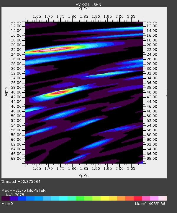
| Estimated Moho Depth: |
21.75 km |
| Estimated Crust Vp/Vs: |
1.71 |
| Assumed Crust Vp: |
6.048 km/s |
| Estimated Crust Vs: |
3.542 km/s |
| Estimated Crust Poisson's Ratio: |
0.24 |
|
| Radial Match: |
90.875084 % |
| Radial Bump: |
357 |
| Transverse Match: |
83.65465 % |
| Transverse Bump: |
400 |
| SOD ConfigId: |
2622 |
| Insert Time: |
2010-03-09 03:24:01.787 +0000 |
| GWidth: |
2.5 |
| Max Bumps: |
400 |
| Tol: |
0.001 |
|

Signal To Noise
| Channel | StoN | STA | LTA |
| MY:KKM: :BHN:20090818T21:31:04.719006Z | 9.724241 | 5.8447523E-7 | 6.0104966E-8 |
| MY:KKM: :BHE:20090818T21:31:04.719006Z | 3.128384 | 1.5366898E-7 | 4.9120878E-8 |
| MY:KKM: :BHZ:20090818T21:31:04.719006Z | 1.9708481 | 1.4295051E-7 | 7.253249E-8 |
| Arrivals |
| Ps | 2.6 SECOND |
| PpPs | 9.4 SECOND |
| PsPs/PpSs | 12 SECOND |


