You are here: Home > Network List > TX - Texas Seismological Network Stations List
> Station DRIO Del Rio > Earthquake Result Viewer
DRIO Del Rio - Earthquake Result Viewer
| Earthquake location: |
Tonga Islands |
| Earthquake latitude/longitude: |
-15.3/-173.6 |
| Earthquake time(UTC): |
2020/11/07 (312) 09:27:04 GMT |
| Earthquake Depth: |
29 km |
| Earthquake Magnitude: |
6.1 Mww |
| Earthquake Catalog/Contributor: |
NEIC PDE/us |
|
| Network: |
TX Texas Seismological Network |
| Station: |
DRIO Del Rio |
| Lat/Lon: |
29.42 N/100.62 W |
| Elevation: |
354 m |
|
| Distance: |
83.2 deg |
| Az: |
57.142 deg |
| Baz: |
248.322 deg |
| Ray Param: |
0.046347316 |
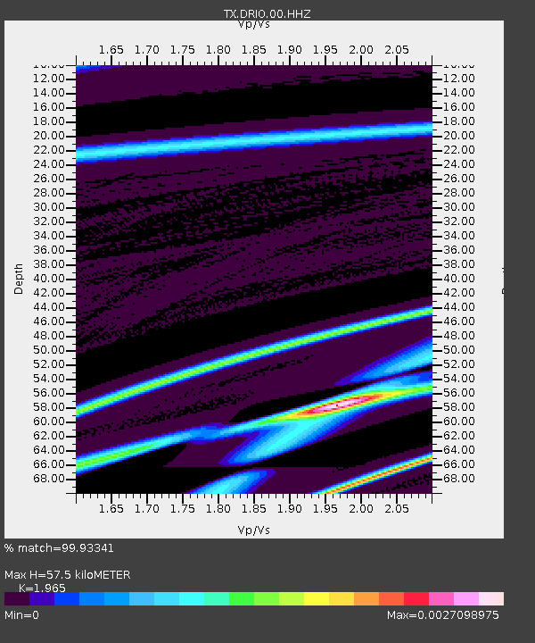
| Estimated Moho Depth: |
57.5 km |
| Estimated Crust Vp/Vs: |
1.97 |
| Assumed Crust Vp: |
6.12 km/s |
| Estimated Crust Vs: |
3.115 km/s |
| Estimated Crust Poisson's Ratio: |
0.33 |
|
| Radial Match: |
99.93341 % |
| Radial Bump: |
10 |
| Transverse Match: |
99.77663 % |
| Transverse Bump: |
33 |
| SOD ConfigId: |
23341671 |
| Insert Time: |
2020-11-21 10:53:57.613 +0000 |
| GWidth: |
2.5 |
| Max Bumps: |
400 |
| Tol: |
0.001 |
|

Signal To Noise
| Channel | StoN | STA | LTA |
| TX:DRIO:00:HHZ:20201107T09:38:56.740008Z | 1.48634 | 6.955268E-8 | 4.6794593E-8 |
| TX:DRIO:00:HH1:20201107T09:38:56.740008Z | 1.4819508 | 3.1741052E-8 | 2.1418426E-8 |
| TX:DRIO:00:HH2:20201107T09:38:56.740008Z | 1.4830666 | 3.5141067E-8 | 2.369487E-8 |
| Arrivals |
| Ps | 9.3 SECOND |
| PpPs | 27 SECOND |
| PsPs/PpSs | 37 SECOND |


